
Harskamp
Harskamp | |
|---|---|
Village | |
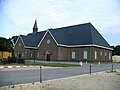
 Church in Harskmap | |
 Harskamp Location in the Netherlands  Harskamp Harskamp (Netherlands) | |
| Coordinates: 52°08′N 5°45′E / 52.133°N 5.750°E | |
| Country | Netherlands |
| Province | Gelderland |
| Municipality | Ede |
| Area | |
| • Total | 35.72 km2 (13.79 sq mi) |
| Elevation | 24 m (79 ft) |
| Population (2021)[1] | |
| • Total | 3,545 |
| • Density | 99/km2 (260/sq mi) |
| Time zone | UTC+1 (CET) |
| • Summer (DST) | UTC+2 (CEST) |
| Postal code | 6732[1] |
| Dialing code | 0318 |
Harskamp is a village in the municipality of Ede in the province of Gelderland, the Netherlands.
It was first mentioned in 1333 as Hoerscampe, and means "horse camp".[3] In 1840, it was home to 268 people.[4] In 1896, a shooting range was built in the village[5] which turned in to the military base Harskamp.[3] The Rehoboth Church was built in 1928.[5]
Points of interest[edit]
-
 WW2 Liberation Monument (by Canadians), 1945
 -
 Another Church
 -
![Windmill Lana Mariana [nl]](//upload.wikimedia.org/wikipedia/commons/thumb/c/cb/Harskampermolen_Mariana.jpg/87px-Harskampermolen_Mariana.jpg) Windmill Lana Mariana
Windmill Lana Mariana


![Windmill Lana Mariana [nl]](/wiki/File:Harskampermolen_Mariana.jpg)
References[edit]
- ^ a b c "Kerncijfers wijken en buurten 2021". Central Bureau of Statistics. Retrieved 22 March 2022.
- ^ "Postcodetool for 6732AA". Actueel Hoogtebestand Nederland (in Dutch). Het Waterschapshuis. Retrieved 22 March 2022.
- ^ a b "Harskamp - (geografische naam)". Etymologiebank (in Dutch). Retrieved 22 March 2022.
- ^ "Harskamp". Plaatsengids (in Dutch). Retrieved 22 March 2022.
- ^ a b Ronald Stenvert & Sabine Broekhoven (2000). "Harskamp" (in Dutch). Zwolle: Waanders. ISBN 90 400 9406 3. Retrieved 22 March 2022.
This Gelderland location article is a stub. You can help Wikipedia by expanding it. |