
Harbarnsen
Harbarnsen | |
|---|---|
 Coat of arms | |
Location of Harbarnsen  | |
 Harbarnsen  Harbarnsen | |
| Coordinates: 51°59′N 09°58′E / 51.983°N 9.967°E | |
| Country | Germany |
| State | Lower Saxony |
| District | Hildesheim |
| Municipality | Lamspringe |
| Area | |
| • Total | 15.03 km2 (5.80 sq mi) |
| Elevation | 189 m (620 ft) |
| Population (2015-12-31) | |
| • Total | 555 |
| • Density | 37/km2 (96/sq mi) |
| Time zone | UTC+01:00 (CET) |
| • Summer (DST) | UTC+02:00 (CEST) |
| Postal codes | 31097 |
| Dialling codes | 05060 |
| Vehicle registration | HI |
Harbarnsen is a village and a former municipality in the district of Hildesheim in Lower Saxony, Germany. Since 1 November 2016, it is part of the municipality Lamspringe.
Geography[edit]
Harbarnsen is situated in an agricultural region between the Weserbergland Schaumburg-Hameln Nature Park and the Harz, roughly 9 km southwest of Bad Salzdetfurth. Surrounding hill ranges, namely Sackwald, Harplage and Heber, are parts of the Lower Saxon Hills.
Division of the municipality[edit]
The municipality of Harbarnsen consisted of two districts, Harbarnsen and Irmenseul.
-
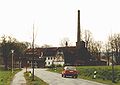 Old distillery in Harbarnsen, 1991
 -
 Irminsul reproduction in Irmenseul


References[edit]
External links[edit]
![]() Media related to Harbarnsen at Wikimedia Commons
Media related to Harbarnsen at Wikimedia Commons
| International | |
|---|---|
| National | |
This Hildesheim district location article is a stub. You can help Wikipedia by expanding it. |