Hanover, Wisconsin
Hanover, Wisconsin | |
|---|---|
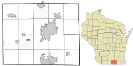
 Location in Rock County and the state of Wisconsin. | |
| Coordinates: 42°38′19″N 89°09′43″W / 42.63861°N 89.16194°W | |
| Country | United States |
| State | Wisconsin |
| County | Rock |
| Area | |
| • Total | 0.574 sq mi (1.49 km2) |
| • Land | 0.574 sq mi (1.49 km2) |
| • Water | 0 sq mi (0 km2) |
| Elevation | 794 ft (242 m) |
| Population (2020) | |
| • Total | 179 |
| • Density | 310/sq mi (120/km2) |
| Time zone | UTC-6 (Central (CST)) |
| • Summer (DST) | UTC-5 (CDT) |
| ZIP Code | 53542[1] |
| Area code | 608 |
| GNIS feature ID | 1566042[2] |
Hanover is an unincorporated census-designated place located in the town of Plymouth, Rock County, Wisconsin, United States. It is west of Janesville and east of Orfordville. As of the 2020 census, its population was 179.[3]
History[edit]
Hanover was originally called Bass Creek.[4] The present name is after Hanover, Germany, the native home of a large share of the early settlers.[4] A post office was established as Bass Creek in 1856 and renamed Hanover in 1859; the post office closed in 2014.[5][6]
Demographics[edit]
This section needs expansion. You can help by adding to it. (January 2023) |
| Census | Pop. | Note | %± |
|---|---|---|---|
| 2010 | 181 | — | |
| 2020 | 179 | −1.1% | |
| U.S. Decennial Census[7] | |||
References[edit]
- ^ "United States ZIP codes". Retrieved February 4, 2023.
- ^ U.S. Geological Survey Geographic Names Information System: Hanover, Wisconsin
- ^ "U.S. Census website". U.S. Census Bureau. Retrieved April 4, 2011.
- ^ a b Chicago and North Western Railway Company (1908). A History of the Origin of the Place Names Connected with the Chicago & North Western and Chicago, St. Paul, Minneapolis & Omaha Railways. p. 81.
- ^ "Rock County". Jim Forte Postal History. Retrieved March 19, 2015.
- ^ Duwe, Gina (August 25, 2014). "The end for 53542: Hanover post office closing this week". Janesville Gazette. Retrieved March 20, 2015.
- ^ "Census of Population and Housing". Census.gov. Retrieved January 1, 2023.

