Grosse-Île, Quebec
Grosse-Île
Grosse-Île | |
|---|---|
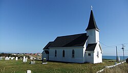
 Saint Peter's By the Sea, Old Harry, Grosse-Île | |
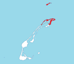
 Location within Les Îles-de-la-Madeleine TE. | |
| Coordinates: 47°37′N 61°31′W / 47.617°N 61.517°W | |
| Country | |
| Province | |
| Region | Gaspésie–Îles-de-la-Madeleine |
| RCM | None |
| Agglomeration | Îles-de-la-Madeleine |
| Constituted | January 1, 2006 |
| Government | |
| • Mayor | Rose Elmonde Clarke |
| • Federal riding | Gaspésie—Îles-de-la-Madeleine |
| • Prov. riding | Îles-de-la-Madeleine |
| Area | |
| • Total | 96.60 km2 (37.30 sq mi) |
| • Land | 32.28 km2 (12.46 sq mi) |
| Population (2021)[2] | |
| • Total | 464 |
| • Density | 14.4/km2 (37/sq mi) |
| • Pop 2006-2011 | |
| • Dwellings | 252 |
| Time zone | UTC−5 (EST) |
| • Summer (DST) | UTC−4 (EDT) |
| Postal code(s) | |
| Area code(s) | 418 and 581 |
| Highways | |
| Website | www |
Grosse-Île is one of two municipalities forming the urban agglomeration of Îles-de-la-Madeleine in Quebec, Canada. It is part of the Gaspésie–Îles-de-la-Madeleine region, and its population was 464 as of the 2021 Census.
History[edit]
As part of a municipal reorganization across Quebec, the seven communities[which?] of the Magdalen Islands amalgamated to form the municipality of Les Îles-de-la-Madeleine on January 1, 2002. However, after a 2004 referendum, Grosse-Île decided to split from the municipality, effective January 1, 2006.[3]
Located on Grosse-Île island (French for Big Island) between the villages of Grande-Entrée (south) and House Harbour (southwest), it was settled during the late 18th century by Scots. French-speaking people would come and establish themselves just after, as seen by a Catholic parish founded in 1793.
Old Harry is a hamlet and fishing village located within the municipal boundaries of Grosse-Île, which lies at the junction of Île de la Grande Ouverte and Île de l'Est. It was first mapped by Joseph Frederick Wallet Des Barres (1769 and 1776) and later by Admiral Henry Wolsey Bayfield (1837), where the name was recorded as Old Harry Head. The toponym derives from Scotsman Harry Clarke, who was for many years the only occupant of the cape (or head). Many of his descendants still bear the surname Clarke.
Hamlets & Villages[edit]
Grosse-Ile and Entry Island is one of the two communities where English is the main language spoken, in the field and at sea, the age-old and daily exchanges have created and still create close relationships between the English- and French-speaking communities and individuals of the archipelago.[4]
The Grande Échourie Beach[edit]
Former name Old-Harry Beach stretches over 9 km between Old Harry Point and East Point where is located the Pointe de l'Est National Wildlife Area, with its unique maritime environment, the area is currently used by more than 150 bird species and 10 or so mammal species.[5]'[6] The Pointe de l'Est National Wildlife Area is located on La Grosse Île, the reserve occupies an area of 748 hectares of the village of Grosse-Île territory's
The hamlet of Old-Harry is located on the point of the same name, in the municipality of Grosse-Île, at the junction of Île de la Grande Entrée and Île de l'Est.[7]
- On Grosse-Île
-
Old-Harry (Hamlet),[8] in port, 5 boats pulled on the wood-covered beach (slips) 1996
Demography[edit]

Population[edit]
| 2021 | 2016 | 2011 | |
|---|---|---|---|
| Population | 464 (-0.2% from 2016) | 465 (-5.1% from 2011) | 490 (-7.7% from 2006) |
| Land area | 32.28 km2 (12.46 sq mi) | 37.59 km2 (14.51 sq mi) | 37.29 km2 (14.40 sq mi) |
| Population density | 14.4/km2 (37/sq mi) | 12.4/km2 (32/sq mi) | 13.1/km2 (34/sq mi) |
| Median age | 52.0 (M: 52.8, F: 51.6) | 49.1 (M: 50.0, F: 48.9) | 43.8 (M: 43.6, F: 44.0) |
| Private dwellings | 252 (total) 220 (occupied) | 254 (total) | 229 (total) |
| Median household income | $86,000 | $81,152 | $.N/A |
|
| ||||||||||||||||||||||||||||||||||||||||||||||||||||||||||||||||||
| [14][2] | |||||||||||||||||||||||||||||||||||||||||||||||||||||||||||||||||||
Language[edit]
| Canada Census Mother Tongue - Grosse-Île, Quebec[14] | ||||||||||||||||||
|---|---|---|---|---|---|---|---|---|---|---|---|---|---|---|---|---|---|---|
| Census | Total | French
|
English
|
French & English
|
Other
| |||||||||||||
| Year | Responses | Count | Trend | Pop % | Count | Trend | Pop % | Count | Trend | Pop % | Count | Trend | Pop % | |||||
2021
|
465
|
65 | 14.0% | 380 | 81.7% | 15 | 3.2% | 0 | 0.0% | |||||||||
2016
|
465
|
60 | 12.9% | 395 | 85.0% | 5 | 1.1% | 5 | 1.1% | |||||||||
2011
|
490
|
50 | 10.2% | 430 | 87.8% | 10 | 2.0% | 0 | 0.0% | |||||||||
2006
|
530
|
25 | 4.7% | 505 | 95.3% | 0 | 0.0% | 0 | 0.0% | |||||||||
2001
|
535
|
75 | 14.0% | 460 | 86.0% | 0 | 0.0% | 0 | 0.0% | |||||||||
1996
|
570
|
60 | n/a | 10.5% | 500 | n/a | 87.7% | 10 | n/a | 1.8% | 0 | n/a | 0.0% | |||||
Salt mining[edit]
Quebec's only salt mine is located on Grosse Île, and is operated by Seleine Mines, which is owned by Windsor Salt.
In 1972, the Société Québécoise d’Exploration Minière (SOQUEM)[15] discovered 7 salt domes,[16] including the one at Grosse-Île. In 1982, after investments of C$125 million, Seleine Mines inaugurated an active underground mine on Grosse Île. In 1988, the company was sold to the Canadian Salt Company (Windsor), and in 2009, the mine passed into the hands of the German group K+S and later to Stone Canyon Industries.
About 150 people work at Seleine Mines, and every year, more than 1,300,000 t (1,300,000 long tons; 1,400,000 short tons) metric tons of salt are extracted there, this salt is used for road deicing.
See also[edit]
References[edit]
- ^ a b "Répertoire des municipalités: Geographic code 01042". www.mamh.gouv.qc.ca (in French). Ministère des Affaires municipales et de l'Habitation.
- ^ a b c "Census Profile, 2021 Census: Grosse-Île, Municipalité [Census subdivision], Quebec". Statistics Canada. Retrieved October 4, 2022.
- ^ "Reconstitution de la Municipalité de Grosse-Île" (PDF). La Gazette officielle du Québec. Retrieved April 5, 2024.
- ^ Stéphanie Arseneau Bussières; Hélène Chevrier (2007). "Socio-economic profile of the Magdalen Islands' English-speaking community". Bibliothèque et Archives nationales du Québec. p. 90. Retrieved March 8, 2024.
Two linguistic communities have shared the archipelago right from its early settlement: the French- and English-speaking communities.
- ^ Miroslav M. Grandtner (May 20, 2017). "A string of islands and beaches, the Magdalen Islands" (PDF) (in French). p. 4. Retrieved March 1, 2024.
All beaches are formed of sand composed of pure quartz.
- ^ "Pointe de l'Est National Wildlife Area". Government of Canada. March 27, 2023. Retrieved March 1, 2024.
Main habitats are dunes, marshes, ponds, barrens, stunted forests
- ^ "Old-Harry". Commission de toponymie Quebec. Government of Quebec. December 1, 1983. Retrieved March 1, 2024.
The hamlet of Old-Harry is located on the point of the same name, in the municipality of Grosse-Île, at the junction of Île de la Grande Entrée and Île de l'Est
- ^ "Sentier vents et marées, carte, étape" (PDF). May 25, 2020. Retrieved March 1, 2024.
Attractions and services, Grosse-Île Église, food, restaurants, Old Harry Museums, beach, shops, CLSC (first aid).
- ^ "2021 Community Profiles". 2021 Canadian Census. Statistics Canada. February 4, 2022. Retrieved October 19, 2023.
- ^ "2016 Community Profiles". 2016 Canadian Census. Statistics Canada. August 12, 2021. Retrieved November 29, 2019.
- ^ "2011 Community Profiles". 2011 Canadian Census. Statistics Canada. March 21, 2019. Retrieved February 23, 2014.
- ^ "2006 Community Profiles". 2006 Canadian Census. Statistics Canada. August 20, 2019.
- ^ "2001 Community Profiles". 2001 Canadian Census. Statistics Canada. July 18, 2021.
- ^ a b Statistics Canada: 1996, 2001, 2006, 2011 census
- ^ "SOQUEM's mineral exploration leader in Quebec". Retrieved March 15, 2024.
The company has participated in hundreds of mining projects that have led to major gold, diamond, and lithium discoveries, as well as the finding of various other mineral deposits.
- ^ "Salt deposits in Quebec" (PDF). Énergies et ressources Québec (in French). Ministère de l'Énergie et des Ressources naturelles - Gouvernement du Québec. November 11, 1979. pp. 40 of 42. Retrieved March 15, 2024.
Deposit located in salt formations where volcanic and clay facies predominate


![Old-Harry (Hamlet),[8] in port, 5 boats pulled on the wood-covered beach (slips) 1996](http://upload.wikimedia.org/wikipedia/commons/thumb/5/55/960630_21a_Grosse_Ile.jpg/273px-960630_21a_Grosse_Ile.jpg)