
Gemert
Gemert | |
|---|---|
Town | |
 Castle of Gemert | |
 Flag  Coat of arms | |
 Gemert Location in the province of North Brabant in the Netherlands  Gemert Gemert (Netherlands) | |
| Coordinates: 51°33′21″N 5°41′12″E / 51.55583°N 5.68667°E | |
| Country | Netherlands |
| Province | North Brabant |
| Municipality | Gemert-Bakel |
| Area | |
| • Total | 19.92 km2 (7.69 sq mi) |
| Elevation | 18 m (59 ft) |
| Population (2021)[1] | |
| • Total | 16,820 |
| • Density | 840/km2 (2,200/sq mi) |
| Time zone | UTC+1 (CET) |
| • Summer (DST) | UTC+2 (CEST) |
| Postal code | 5420-5422[1] |
| Dialing code | 0492 |
Gemert is a town in the Dutch province of North Brabant. It is located in the municipality of Gemert-Bakel.
Gemert was a separate municipality until 1997, when it merged with Bakel.[3]
The spoken language is Peellands (an East Brabantian dialect, which is very similar to colloquial Dutch).[4]
Population centres[edit]
The population centres from Gemert are Handel, De Mortel and Elsendorp. Gemert also has a little chapel village called Esdonk and a Protestant mining village called Vossenberg.
Notable people born in Gemert[edit]
Places of interest[edit]
Castle and Castle Park[edit]
The construction of the castle began in 1391. Till 1794 the castle was used by the German Order. In 1916 the castle was used as a mission monastic. The castle has a Castle Park in English style. In the park there is also the liberation monument from World War II.
Museums[edit]
Het Boerenbondsmuseum is a museum in Gemert. In this museum there are some objects and some buildings about the farmerpopulation near Gemert around 1900.
Religious buildings[edit]
Gemert has two churches:
- De Kerk van Sint-Jans Onthoofding.
- Sint-Gerardus Majellakerk.
Gemert has also one monastery:
- Klooster Nazareth.
Gallery[edit]
-
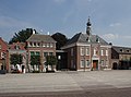 Town hall
 -
 Building in Gemert
 -
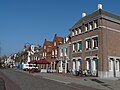 Street view
 -
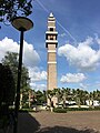 Tower of the St Gerardus Majella Church


References[edit]
- ^ a b c "Kerncijfers wijken en buurten 2021". Central Bureau of Statistics. Retrieved 16 April 2022.
- ^ "Postcodetool for 5421AA". Actueel Hoogtebestand Nederland (in Dutch). Het Waterschapshuis. Retrieved 16 April 2022.
- ^ Ad van der Meer and Onno Boonstra, Repertorium van Nederlandse gemeenten, KNAW, 2011.
- ^ Jos & Cor Swanenberg: Taal in stad en land: Oost-Brabants, ISBN 9012090105