
Gap Mountain (Alberta)
| Gap Mountain | |
|---|---|
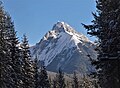
 Gap Mountain from Highway 40 at Highwood Pass | |
| Highest point | |
| Elevation | 2,675 m (8,776 ft)[1] |
| Prominence | 282 m (925 ft)[1] |
| Parent peak | Elpoca Mountain (3,036 m)[1] |
| Listing | Mountains of Alberta |
| Coordinates | 50°39′22″N 115°03′15″W / 50.65611°N 115.05417°W[2] |
| Geography | |
 Gap Mountain Location of Gap Mountain in Alberta  Gap Mountain Gap Mountain (Canada) | |
| Location | Alberta, Canada |
| Parent range | Opal Range[3] Canadian Rockies |
| Topo map | NTS 82J11 Kananaskis Lakes[2] |
| Geology | |
| Age of rock | Cambrian |
| Type of rock | Limestone[3] |
| Climbing | |
| Easiest route | Scramble on eastern side[4] |
Gap Mountain is a 2,675-metre (8,776-foot) mountain summit located at the southern end of the Opal Range in the Canadian Rockies of Alberta, Canada.[1] The nearest higher neighbor is Elpoca Mountain, 2.0 km (1.2 mi) to the east.[1] Gap Mountain is situated 5.0 km south of Mount Wintour, within Peter Lougheed Provincial Park. Gap Mountain is a conspicuous peak seen from Alberta Highway 40 at Highwood Pass. It is a popular climbing destination because it offers interesting, exposed scrambling on its eastern flanks with excellent summit views of Kananaskis Country.[3]
History[edit]
George Pocaterra named it for its location at the gap between the Opal Range and Elk Range.[1] The mountain's toponym was officially adopted in 1978 by the Geographical Names Board of Canada.[2]
Geology[edit]
Gap Mountain is composed of limestone laid down during the Precambrian to Jurassic periods. Formed in shallow seas, this sedimentary rock was pushed east and over the top of younger rock during the Laramide orogeny.[5] Gap Mountain was created during the Lewis Overthrust. The steeply tilted strata are virtually the same in each peak of the Opal Range, with softer layers sandwiched between harder layers.[1]
Climate[edit]
Based on the Köppen climate classification, Gap Mountain is located in a subarctic climate zone with cold, snowy winters, and mild summers.[6] Temperatures can drop below −20 °C with wind chill factors below −30 °C.
June through September offer the most favorable weather to climb or view Gap Mountain.
Precipitation runoff from the mountain drains into Pocaterra Creek, a tributary of the Kananaskis River.
See also[edit]
Gallery[edit]
-
 Southwest aspect in winter
 -
 Northwest aspect in winter
 -
 Highwood Pass and Gap Mountain
 -
 Gap Mountain (left) and Elpoca Mountain (right)


References[edit]
- ^ a b c d e f g "Gap Mountain". Bivouac.com. Retrieved 2018-11-28.
- ^ a b c "Gap Mountain". Geographical Names Data Base. Natural Resources Canada. Retrieved 2018-11-28.
- ^ a b c "Gap Mountain, Alberta". Peakbagger.com. Retrieved 2019-09-08.
- ^ Kane, Alan (1999). "Gap Mountain". Scrambles in the Canadian Rockies. Calgary: Rocky Mountain Books. pp. 152–153. ISBN 0-921102-67-4.
- ^ Gadd, Ben (2008). Geology of the Rocky Mountains and Columbias.
- ^ Peel, M. C.; Finlayson, B. L.; McMahon, T. A. (2007). "Updated world map of the Köppen−Geiger climate classification". Hydrol. Earth Syst. Sci. 11: 1633–1644. ISSN 1027-5606.
External links[edit]
- Gap Mountain weather: Mountain Forecast
- Gap Mountain winter photo: Flickr