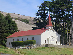
Forts Baker, Barry, and Cronkhite
Forts Baker, Barry, and Cronkhite | |
 | |
| Nearest city | Sausalito, California |
|---|---|
| Area | 25 acres (10 ha) |
| Built | 1867 |
| Architectural style | Stick/eastlake |
| NRHP reference No. | 73000255[1] |
| Added to NRHP | December 12, 1973 |
Forts Baker, Barry, and Cronkhite near Sausalito, California is a combination of historic sites that, as a group, was listed on the National Register of Historic Places (NRHP) in 1973. Fort Baker is a major part.
It includes or is associated with the Lime Point Tract Reservation and the Tennessee Point Military Reservation.[1] The Lime Point Tract Reservation is a historic name for Fort Baker, which became the new name in 1897.
The NRHP listing included one contributing building, 14 contributing structures and three contributing sites, with an area of 25 acres (10 ha).[1]
Cavallo Point, now a conference center or hotel, is included.
There is at least one notable example of Stick/Eastlake architecture included.[2]
Gallery[edit]
See also[edit]
- Fort Baker
- Fort Barry
- Fort Cronkhite
- Baker–Barry Tunnel
References[edit]
- ^ a b c "National Register Information System". National Register of Historic Places. National Park Service. July 9, 2010.
- ^ "National Register of Historic Places Inventory/Nomination: Forts Baker, Barry, and Cronkhite". National Park Service. and accompanying photos
Further reading[edit]
- Haller, Stephen A. (2010). The last missile site: an operational and physical history of Nike Site SF-88, Fort Barry, California. Bodega Bay, Calif: Hole in the Head Press. ISBN 9780976149415.
External links[edit]
Wikimedia Commons has media related to Forts Baker, Barry, and Cronkhite Historic District.
Categories:
- Forts in California
- Golden Gate National Recreation Area
- Buildings and structures in Marin County, California
- Closed installations of the United States Army
- Formerly Used Defense Sites in California
- Military facilities in the San Francisco Bay Area
- Historic district contributing properties in California
- Forts on the National Register of Historic Places in California
- Tourist attractions in Marin County, California
- Queen Anne architecture in California
- Victorian architecture in California
- Historic districts on the National Register of Historic Places in California
- National Register of Historic Places in Marin County, California


