Foieni
Foieni
Mezőfény, Fienen | |
|---|---|
 Panoramic view of Foieni | |
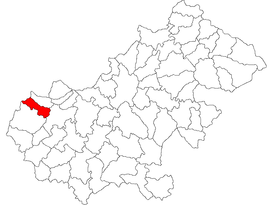
 Location in Satu Mare County | |
| Coordinates: 47°42′N 22°23′E / 47.700°N 22.383°E | |
| Country | Romania |
| County | Satu Mare |
| Government | |
| • Mayor (2020–2024) | László Brém[1] (UDMR) |
| Area | 40.45 km2 (15.62 sq mi) |
| Elevation | 124 m (407 ft) |
| Population (2021-12-01)[2] | 1,725 |
| • Density | 43/km2 (110/sq mi) |
| Time zone | EET/EEST (UTC+2/+3) |
| Postal code | 447135 |
| Vehicle reg. | SM |
| Website | www |
Foieni (Hungarian: Mezőfény, Hungarian pronunciation: [mɛzøːfeːni]; German: Fienen) is a commune of 1,836 inhabitants situated in Satu Mare County, Romania. It is composed of a single village, Foieni.
The commune is located in the western part of the county, at a distance of 6 km (3.7 mi) from Carei and 40 km (25 mi) from the county seat, Satu Mare. It borders Hungary to the west, the city of Carei to the east, Ciumești commune to the south, and Urziceni commune to the north.[3]
The Foieni sand dunes is a 10 ha (25 acres) protected area located on the territory of the commune.
Demographics[edit]
Ethnic groups (2011 census):[4]
- Hungarians: 69% (55.52% in 2002[5])
- Germans: 21.1% (41.60% in 2002)
- Romanis: 5.6% (0.00% in 2002)
- Romanians: 3.7% (2.81% in 2002)
According to mother tongue, 96.38% of the population speak Hungarian as their first language.
References[edit]
- ^ "Results of the 2020 local elections". Central Electoral Bureau. Retrieved 17 June 2021.
- ^ "Populaţia rezidentă după grupa de vârstă, pe județe și municipii, orașe, comune, la 1 decembrie 2021" (XLS). National Institute of Statistics.
- ^ "Așezarea comunei" (in Romanian). Foieni townhall. Retrieved June 17, 2021.
- ^ [1] Archived 2017-02-02 at the Wayback Machine
- ^ "Structura Etno-demografică a României". Edrc.ro. Retrieved 26 May 2018.


