
File:View of Oil House (left) and Fog Signal House (right), looking east - Great Captain Island Light, Great Captain Island, Greenwich, Fairfield County, CT HAER CONN,1-GREWI.V,.2-12.tif

Size of this JPG preview of this TIF file: 744 × 600 pixels. Other resolutions: 298 × 240 pixels | 595 × 480 pixels | 953 × 768 pixels | 1,270 × 1,024 pixels | 2,540 × 2,048 pixels | 5,089 × 4,103 pixels.
Original file (5,089 × 4,103 pixels, file size: 19.92 MB, MIME type: image/tiff)
| This is a file from the Wikimedia Commons. Information from its description page there is shown below. Commons is a freely licensed media file repository. You can help. |
Summary
| View of Oil House (left) and Fog Signal House (right), looking east - Great Captain Island Light, Great Captain Island, Greenwich, Fairfield County, CT | ||||
|---|---|---|---|---|
| Photographer |
Brewster, Robert, creator |
|||
| Title |
View of Oil House (left) and Fog Signal House (right), looking east - Great Captain Island Light, Great Captain Island, Greenwich, Fairfield County, CT |
|||
| Depicted place | Connecticut; Fairfield County; Greenwich | |||
| Date | 1999 | |||
| Dimensions | 4 x 5 in. | |||
| Current location |
Library of Congress Prints and Photographs Division Washington, D.C. 20540 USA http://hdl.loc.gov/loc.pnp/pp.print |
|||
| Accession number |
HAER CONN,1-GREWI.V,.2-12 |
|||
| Credit line |
|
|||
| Source | https://www.loc.gov/pictures/item/ct0669.photos.383709p | |||
| Permission (Reusing this file) |
|
|||

File history
Click on a date/time to view the file as it appeared at that time.
| Date/Time | Thumbnail | Dimensions | User | Comment | |
|---|---|---|---|---|---|
| current | 01:12, 9 July 2014 | 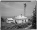 | 5,089 × 4,103 (19.92 MB) | Fæ | GWToolset: Creating mediafile for Fæ. HABS 06 July 2014 (611:700) |
File usage
The following pages on the English Wikipedia use this file (pages on other projects are not listed):
Global file usage
The following other wikis use this file:
- Usage on de.wikipedia.org
- Usage on www.wikidata.org