
File:Mount-gretna-map.tif

Size of this JPG preview of this TIF file: 800 × 520 pixels. Other resolutions: 320 × 208 pixels | 640 × 416 pixels | 1,024 × 665 pixels | 1,280 × 831 pixels | 2,560 × 1,663 pixels | 10,210 × 6,631 pixels.
Original file (10,210 × 6,631 pixels, file size: 64.57 MB, MIME type: image/tiff)
| This is a file from the Wikimedia Commons. Information from its description page there is shown below. Commons is a freely licensed media file repository. You can help. |
Summary
| Description |
English: Map of Mount Gretna, Pennsylvania |
| Date | 1980s |
| Source | Scan of free handout |
| Author | The Mount Gretna Fire Company |
Licensing
This file is in the public domain because it is a scan of a complimentary handout from The Mount Gretna Fire Company
|
File history
Click on a date/time to view the file as it appeared at that time.
| Date/Time | Thumbnail | Dimensions | User | Comment | |
|---|---|---|---|---|---|
| current | 14:34, 26 January 2023 | 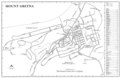 | 10,210 × 6,631 (64.57 MB) | N-gio | Uploaded a work by The Mount Gretna Fire Company from Scan of free handout with UploadWizard |
File usage
The following pages on the English Wikipedia use this file (pages on other projects are not listed):