
File:LHD Supplement AK.pdf
Size of this JPG preview of this PDF file: 425 × 599 pixels. Other resolutions: 170 × 240 pixels | 340 × 480 pixels | 544 × 768 pixels | 1,245 × 1,756 pixels.
Original file (1,245 × 1,756 pixels, file size: 644 KB, MIME type: application/pdf)
| This is a file from the Wikimedia Commons. Information from its description page there is shown below. Commons is a freely licensed media file repository. You can help. |
Summary
| Description |
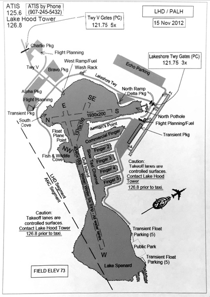
English: Lake Hood Seaplane Base (PALH / LHD) diagram including waterlanes, parking areas and radio frequencies. Published in Supplement Alaska, 27 APR 2017 |
| Date | |
| Source | https://www.faa.gov/air_traffic/flight_info/aeronav/digital_products/dafd/ |
| Author | Federal Aviation Administration, Alaskan Region |
| Camera location | | View this and other nearby images on: OpenStreetMap |
|---|
Licensing
This image or file is a work of a Federal Aviation Administration employee, taken or made as part of that person's official duties. As a work of the U.S. federal government, the image is in the public domain in the United States.
|
 |
File history
Click on a date/time to view the file as it appeared at that time.
| Date/Time | Thumbnail | Dimensions | User | Comment | |
|---|---|---|---|---|---|
| current | 21:19, 10 May 2017 |  | 1,245 × 1,756 (644 KB) | N727RH | User created page with UploadWizard |
File usage
The following pages on the English Wikipedia use this file (pages on other projects are not listed):
Global file usage
The following other wikis use this file:
- Usage on zh.wikipedia.org