Falmouth, Michigan
Falmouth, Michigan | |
|---|---|
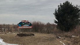
 Welcome sign to Falmouth (February 2018) | |
| Coordinates: 44°14′36″N 85°05′13″W / 44.24333°N 85.08694°W | |
| Country | United States |
| State | Michigan |
| County | Missaukee |
| Township | Clam Union |
| Settled | 1871 |
| Area | |
| • Total | 0.68 sq mi (1.76 km2) |
| • Land | 0.68 sq mi (1.76 km2) |
| • Water | 0.00 sq mi (0.00 km2) |
| Population | |
| • Total | 183 |
| • Density | 269.12/sq mi (103.95/km2) |
| Time zone | UTC-5 (Eastern (EST)) |
| • Summer (DST) | UTC-4 (EDT) |
| ZIP Code | 49632 |
| Area code | 231 |
| GNIS feature ID | 625817[3] |
| FIPS code | 26-27320 |
Falmouth is an unincorporated community and census-designated place (CDP) in Missaukee County in the U.S. state of Michigan.[3] The community is located within Clam Union Township. Its population was 183 at the 2020 census.[2]
History[edit]
It began as a lumbering settlement and was first known as Pinhook. A post office named Falmouth was established on December 18, 1871,[4] with Eugene W. Watson as the first postmaster. In 1873, Falmouth nearly became the county seat, losing to Reeder (now Lake City) by one vote. John Koopman built a store in 1879, and in 1881 bought the village plat, along with its saw, shingle and grist mill.[5]
Geography[edit]
Falmouth is in southern Missaukee County, in the northwest corner of Clam Union Township. It is 12 miles (19 km) by road southeast of Lake City, the county seat, and 9 miles (14 km) northeast of McBain.
According to the U.S. Census Bureau, the Falmouth CDP has an area of 0.68 square miles (1.76 km2), all of if recorded as land.[1] The Clam River, a south-flowing tributary of the Muskegon River, runs along the southwest edge of the community.
Demographics[edit]
This section needs expansion. You can help by adding to it. (January 2023) |
| Census | Pop. | Note | %± |
|---|---|---|---|
| 2020 | 183 | — | |
| U.S. Decennial Census[6] | |||
Transportation[edit]
The main roads that provide access to Falmouth are Prosper Road (to the east), 7 Mile Road (to the northeast), Forward Road (to the north and south), and Falmouth Road (to the west.
References[edit]
- ^ a b "2023 U.S. Gazetteer Files: Michigan". United States Census Bureau. Retrieved October 23, 2023.
- ^ a b "P1. Race – Falmouth CDP, Michigan: 2020 DEC Redistricting Data (PL 94-171)". U.S. Census Bureau. Retrieved October 23, 2023.
- ^ a b U.S. Geological Survey Geographic Names Information System: Falmouth, Michigan
- ^ U.S. Geological Survey Geographic Names Information System: Falmouth Post Office
- ^ Romig, Walter (1986) [1973]. Michigan Place Names. Detroit, Michigan: Wayne State University Press. ISBN 0-8143-1838-X.
- ^ "Census of Population and Housing". Census.gov. Retrieved June 4, 2016.


