
Epaulette Mountain
| Epaulette Mountain | |
|---|---|
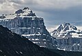
 Epaulette Mountain seen from Icefields Parkway | |
| Highest point | |
| Elevation | 3,094 m (10,151 ft)[1] |
| Prominence | 259 m (850 ft)[1] |
| Parent peak | Mount Chephren (3274 m)[1] |
| Isolation | 3.64 km (2.26 mi)[2] |
| Listing | Mountains of Alberta |
| Coordinates | 51°51′57″N 116°44′06″W / 51.86583°N 116.73500°W[3] |
| Geography | |
 Epaulette Mountain Location of Epaulette Mountain in Alberta  Epaulette Mountain Epaulette Mountain (Canada) | |
| Location | Alberta, Canada |
| Parent range | Waputik Mountains Canadian Rockies |
| Topo map | NTS 82N15 Mistaya Lake[3] |
| Geology | |
| Age of rock | Cambrian |
| Type of rock | Sedimentary |
| Climbing | |
| First ascent | 1924 by F.V. Field, W.O. Field, Edward Feuz Jr.(guide)[4] |
| Easiest route | technical climb |
Epaulette Mountain is a 3,094-metre (10,151-foot) mountain summit in Alberta, Canada.
Description[edit]
Epaulette Mountain is located in Banff National Park and is visible from the Icefields Parkway. It is part of the Waputik Mountains, a subrange of the Canadian Rockies. The nearest higher peak is Mount Sarbach, 3.64 km (2.26 mi) to the northwest.[2] Epaulette Mountain is situated south of Saskatchewan Crossing, where the Icefields Parkway intersects with the David Thompson Highway. Precipitation runoff from Epaulette Mountain drains east into the Mistaya River and west into Howse River, which are both tributaries of the North Saskatchewan River. Topographic relief is significant as the summit rises 1,600 meters (5,250 feet) above the Howse Valley in three kilometers (1.9 miles), and 1,400 meters (4,593 feet) above the Mistaya Valley in three kilometers.
History[edit]
The first ascent of Epaulette Mountain was made in 1924 by Frederick Vanderbilt Field, William Osgood Field, and guide Edward Feuz Jr.[4] The mountain's toponym was officially adopted June 7, 1961, by the Geographical Names Board of Canada.[3] The descriptive name refers to the shoulder ornament on some military uniforms, and how a glacier seems to hang on a narrow shelf above the steep cliffs, thought to resemble an epaulette. Epaulette is a French word which means "little shoulders" (epaule, referring to "shoulder").[1]
Geology[edit]
Like other mountains in Banff Park, the Epaulette Mountain is composed of sedimentary rock laid down during the Precambrian to Jurassic periods.[5] Formed in shallow seas, this sedimentary rock was pushed east and over the top of younger rock during the Laramide orogeny.[6]
Climate[edit]
Based on the Köppen climate classification, Epaulette Mountain is located in a subarctic climate zone with cold, snowy winters, and mild summers.[7] Winter temperatures can drop below -20 °C with wind chill factors below -30 °C.
See also[edit]
Gallery[edit]
-
 Epaulette Mountain from Waterfowl Lakes
 -
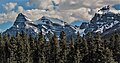
 Epaulette Mountain (left) and Kaufmann Peaks (right) viewed from southeast along Icefields Parkway
 -
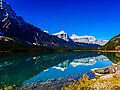 Epaulette Mountain (centered) reflected in Waterfowl Lakes
 -
 Mount Chephren (left) and Epaulette Mountain (right)
 -
 Mount Chephren (left), White Pyramid, Epaulette Mountain (right)
 -
 View looking south from Saskatchewan Crossing. Left to rightː Mt. Chephren, White Pyramid, Epaulette Mountain (centre), Kaufmann Peaks, Mt. Sarbach.


.jpg)


References[edit]
- ^ a b c d "Epaulette Mountain". Bivouac.com. Retrieved October 14, 2018.
- ^ a b "Epaulette Mountain, Alberta". Peakbagger.com. Retrieved November 10, 2019.
- ^ a b c "Epaulette Mountain". Geographical Names Data Base. Natural Resources Canada. Retrieved October 15, 2018.
- ^ a b "Epaulette Mountain". cdnrockiesdatabases.ca. Retrieved October 15, 2018.
- ^ Belyea, Helen R. (1960). The Story of the Mountains in Banff National Park (PDF). parkscanadahistory.com (Report). Ottawa: Geological Survey of Canada. Archived (PDF) from the original on October 2, 2015. Retrieved September 13, 2019.
- ^ Gadd, Ben (2008). Geology of the Rocky Mountains and Columbias.
- ^ Peel, M. C.; Finlayson, B. L.; McMahon, T. A. (2007). "Updated world map of the Köppen−Geiger climate classification". Hydrol. Earth Syst. Sci. 11: 1633–1644. ISSN 1027-5606.
External links[edit]
- Weather forecast: Epaulette Mountain
- Parks Canada web site: Banff National Park
Places adjacent to Epaulette Mountain | ||||||||||||||||
|---|---|---|---|---|---|---|---|---|---|---|---|---|---|---|---|---|
| ||||||||||||||||