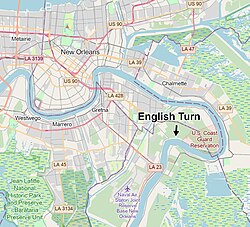
English Turn
This article has multiple issues. Please help improve it or discuss these issues on the talk page. (Learn how and when to remove these template messages)
|
English Turn | |
|---|---|
 Map of the English Turn in relation to New Orleans | |
| Coordinates: 29°53′N 89°58′W / 29.88°N 89.96°W | |
| Location | Southeast of New Orleans |
| Part of | Lower Mississippi River |
English Turn is a bend in the Mississippi River in New Orleans, Louisiana.
Etymology[edit]
In 1699, French explorers Sauvolle and Jean-Baptiste Le Moyne de Bienville were exploring the lower Mississippi and encountered English ships. Bienville was successful in ordering the English out of the river, and the event left the name, English Turn, on the bend. [1][2][3]
References[edit]
- ^ O’Neill, C (1974). "LE MOYNE DE BIENVILLE, JEAN-BAPTISTE". University of Toronto/Université Laval. Retrieved 2021-03-05.
- ^ "Historical collections of Louisiana and Florida – including translations of original manuscripts relating to their discovery and settlement, with numerous historical and biographical notes". 1869.
- ^ Scott, Mike (5 April 2017). "Recalling the single biggest con in New Orleans history". NOLA.com. The Times-Picayune. Retrieved 4 December 2022.

