
Engelberger Aa
| Engelberger Aa | |
|---|---|
 The Aaschlucht gorge | |
| Location | |
| Country | Switzerland |
| Physical characteristics | |
| Source | |
| • location | West of Surenenpass |
| Mouth | Lake Lucerne |
• coordinates | 46°58′44″N 8°25′31″E / 46.97889°N 8.42528°E |
• elevation | 433 m (1,421 ft) |
| Length | 50 km (31 mi) |
| Basin size | 230 km2 (89 sq mi) |
| Basin features | |
| Progression | Lake Lucerne→ Reuss→ Aare→ Rhine→ North Sea |
Engelberger Aa | ||||||||||||||||||||||||||||||||||||||||||||||||||||||||||||||||||||||||||||||||||||||||||||||||||||||||||||||||||||||||||||||||||||||||||||||||||||||||||||||||||||||||||||||||||||||||||||||||||||||||||||||||||||||||||||||||||||||||||||||||||||||||||||||||||||||||||||||||||||||||||||||||||||||||||||||||||||||||||||||||||||||||||||||||||||||||||||||||||||||||||||||||||||||||||||||||||||||||||||||||||||||||||||||||||||||||||||||||||||||||||||||||||||||||||||||||||||||||||||||||||||||||||||||||||||||||||||||||||||||||||||||||||||||||||||||||||||||||||||||||||||||||||||||||||||||||||||||||||||||||||||||||||||||||||||||||||||||||||||||||||||||||||||||||||||||||||||||||||||||||||||||||||||||||||||||||||||||||||||||||||||||||||||||||||||||||||||||||||||||
|---|---|---|---|---|---|---|---|---|---|---|---|---|---|---|---|---|---|---|---|---|---|---|---|---|---|---|---|---|---|---|---|---|---|---|---|---|---|---|---|---|---|---|---|---|---|---|---|---|---|---|---|---|---|---|---|---|---|---|---|---|---|---|---|---|---|---|---|---|---|---|---|---|---|---|---|---|---|---|---|---|---|---|---|---|---|---|---|---|---|---|---|---|---|---|---|---|---|---|---|---|---|---|---|---|---|---|---|---|---|---|---|---|---|---|---|---|---|---|---|---|---|---|---|---|---|---|---|---|---|---|---|---|---|---|---|---|---|---|---|---|---|---|---|---|---|---|---|---|---|---|---|---|---|---|---|---|---|---|---|---|---|---|---|---|---|---|---|---|---|---|---|---|---|---|---|---|---|---|---|---|---|---|---|---|---|---|---|---|---|---|---|---|---|---|---|---|---|---|---|---|---|---|---|---|---|---|---|---|---|---|---|---|---|---|---|---|---|---|---|---|---|---|---|---|---|---|---|---|---|---|---|---|---|---|---|---|---|---|---|---|---|---|---|---|---|---|---|---|---|---|---|---|---|---|---|---|---|---|---|---|---|---|---|---|---|---|---|---|---|---|---|---|---|---|---|---|---|---|---|---|---|---|---|---|---|---|---|---|---|---|---|---|---|---|---|---|---|---|---|---|---|---|---|---|---|---|---|---|---|---|---|---|---|---|---|---|---|---|---|---|---|---|---|---|---|---|---|---|---|---|---|---|---|---|---|---|---|---|---|---|---|---|---|---|---|---|---|---|---|---|---|---|---|---|---|---|---|---|---|---|---|---|---|---|---|---|---|---|---|---|---|---|---|---|---|---|---|---|---|---|---|---|---|---|---|---|---|---|---|---|---|---|---|---|---|---|---|---|---|---|---|---|---|---|---|---|---|---|---|---|---|---|---|---|---|---|---|---|---|---|---|---|---|---|---|---|---|---|---|---|---|---|---|---|---|---|---|---|---|---|---|---|---|---|---|---|---|---|---|---|---|---|---|---|---|---|---|---|---|---|---|---|---|---|---|---|---|---|---|---|---|---|---|---|---|---|---|---|---|---|---|---|---|---|---|---|---|---|---|---|---|---|---|---|---|---|---|---|---|---|---|---|---|---|---|---|---|---|---|---|---|---|---|---|---|---|---|---|---|---|---|---|---|---|---|---|---|---|---|---|---|---|---|---|---|---|---|---|---|---|---|---|---|---|---|---|---|---|---|---|---|---|---|---|---|---|---|---|---|---|---|---|---|---|---|---|---|---|---|---|---|---|---|---|---|---|---|---|---|---|---|---|---|---|---|---|---|---|---|---|---|---|---|---|---|---|---|---|---|---|---|---|---|---|---|---|---|---|---|---|---|---|---|---|---|---|---|---|---|---|---|---|---|---|---|---|---|---|---|---|---|---|---|---|---|---|---|---|---|---|---|---|---|---|---|---|---|---|---|---|---|---|---|---|---|---|---|---|---|---|---|---|---|---|---|---|---|---|---|---|---|---|---|---|---|---|---|---|---|---|---|---|---|---|---|---|---|---|---|---|---|---|---|---|---|---|---|---|---|---|---|---|---|---|---|---|---|---|---|---|---|---|---|---|---|---|---|---|---|---|---|---|---|---|---|---|---|---|---|---|---|---|---|---|---|---|---|---|---|---|---|---|---|---|---|---|---|---|---|---|---|---|---|---|---|---|---|---|
| ||||||||||||||||||||||||||||||||||||||||||||||||||||||||||||||||||||||||||||||||||||||||||||||||||||||||||||||||||||||||||||||||||||||||||||||||||||||||||||||||||||||||||||||||||||||||||||||||||||||||||||||||||||||||||||||||||||||||||||||||||||||||||||||||||||||||||||||||||||||||||||||||||||||||||||||||||||||||||||||||||||||||||||||||||||||||||||||||||||||||||||||||||||||||||||||||||||||||||||||||||||||||||||||||||||||||||||||||||||||||||||||||||||||||||||||||||||||||||||||||||||||||||||||||||||||||||||||||||||||||||||||||||||||||||||||||||||||||||||||||||||||||||||||||||||||||||||||||||||||||||||||||||||||||||||||||||||||||||||||||||||||||||||||||||||||||||||||||||||||||||||||||||||||||||||||||||||||||||||||||||||||||||||||||||||||||||||||||||||||
The Engelberger Aa (or Engelbergeraa) is a river in Switzerland. It rises west of the Surenenpass in the Canton of Uri, flows through the valley of Engelberg (Obwalden) and Nidwalden. At Buochs it flows into Lake Lucerne and is therefore a tributary of the Reuss, which drains the lake.
Route[edit]
The source of the river is at an altitude of approximately 2,200 m (7,200 ft), a few hundred metres to the west of the Surenenpass ridge. From here it flows westwards, descending rapidly and collecting many mountain streams. It roughly follows the route of the Surenenpass hiking trail to Blackenalp (1,760 m (5,770 ft)), the first farm dwelling along the route. At this point it is still a mountain stream and is named the Stierenbach. Below Blackenalp are the two Stäuber waterfalls (1,600 m (5,200 ft)) which fall steeply to the valley floor.
The stream continues westwards, past the Stäfeli (1,392 m (4,567 ft)) and Alpenrösli farms, and just past the latter crosses into the canton of Obwalden. From here on the river is named the Engelberger Aa. More streams from both sides of the valley join the river as it forms a wide gravel course. Flood defences have been constructed in this area to protect the town below.
Past Herrenrüti and Eienwäldli, the river flows under the Bänklialp bridge and past Engelberg town (1,000 m (3,300 ft)). It flows to the south of the Eugenisee hydroelectric reservoir but does not normally feed into it; the inflow from the Erlenbach and down from Trüebsee via the power station is usually enough to maintain required levels.
After Örtigen on the outskirts of Engelberg the river turns northwards and starts to descend a steep gorge, the Aaschlucht (possibly named as a play on words referring to the Aareschlucht). Here a hiking trail, the Erlebnisweg Aaschlucht (the "Aa Gorge Discovery Way") follows the river, crossing over it via a total of eleven foot and suspension bridges. After the confluence with the Arnibach the river forms the border between the cantons of Obwalden and Nidwalden, continuing until just past Grafenort after which the river remains in Nidwalden for the remainder of its route. The Aasclucht trail ends at Obermatt (658 m (2,159 ft)) alongside another power station reservoir.
The river continues along the valley, now flowing mostly level but still with the potential for high water during flood seasons. It follows the Luzern-Stans-Engelberg railway line and the 374 road, past the villages of Grafenort, Wolfenschiessen and Dallenwil. Along this part of the route it is sometimes named the Aawasser.
There is a dammed channel feeding a power station at Hostetten, and soon after that the river turns eastwards and crosses under the A2 autobahn. Finally the river flows through the town of Buochs and enters Lake Lucerne alongside the Aawasseregg beach (435 m (1,427 ft)).
Gallery[edit]
-
 The Stäuber waterfalls below Blackenalp
 -
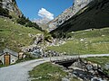 Bridge over the Stierenbach near Stäfeli
 -
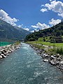 The river passing Engelberg
 -
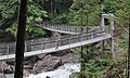 Suspension foot bridges in the Aaschlucht
 -
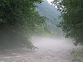 The river in fog near Wolfenschiessen
 -
 Old and new Fädenbrücke bridges near Buochs


This Nidwalden location article is a stub. You can help Wikipedia by expanding it. |
This Obwalden location article is a stub. You can help Wikipedia by expanding it. |
This Canton of Uri location article is a stub. You can help Wikipedia by expanding it. |