
El Capitan (Idaho)
| El Capitan | |
|---|---|
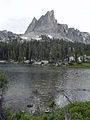
 El Capitan and Alice Lake | |
| Highest point | |
| Elevation | 9,901 ft (3,018 m) |
| Prominence | 437 ft (133 m)[1] |
| Parent peak | Peak 10,052 |
| Coordinates | 43°56′28″N 114°56′02″W / 43.9410156°N 114.9339651°W[2] |
| Geography | |
 El Capitan Location in the United States  El Capitan Location in Idaho | |
| Location | Blaine County, Idaho, U.S. |
| Parent range | Sawtooth Range |
| Topo map | USGS Snowyside Peak |
| Climbing | |
| Easiest route | Scrambling, class 3 |
El Capitan (9,901 feet (3,018 m)) is a mountain in the western United States, in the Sawtooth Range of central Idaho. Located in the Sawtooth Wilderness of Sawtooth National Recreation Area in Blaine County, it is 1.2 miles (1.9 km) south-southeast of Peak 10,052, its line parent.
El Capitan is 1.9 miles (3.1 km) east of Snowyside Peak and 1.4 miles (2.3 km) west of McDonald Peak. It rises above the eastern end of Alice Lake, with a surface elevation of 8,600 feet (2,620 m) above sea level,[3][4][5] accessed by the moderate trail from Pettit Lake at 7,000 feet (2,130 m).
-
 El Capitan

References[edit]
- ^ "El Capitan, Idaho". Peakbagger.com. Retrieved January 4, 2013.
- ^ "El Capitan". Geographic Names Information System. United States Geological Survey, United States Department of the Interior. Retrieved January 4, 2013.
- ^ Sawtooth National Forest (Map) (1998 ed.). Sawtooth National Forest, U.S. Forest Service.
- ^ "El Capitan". SummitPost.org. Retrieved January 4, 2013.
- ^ "El Capitan". Lists of John. Retrieved January 4, 2013.
This Blaine County, Idaho state location article is a stub. You can help Wikipedia by expanding it. |