
Dussen
Dussen | |
|---|---|
Village | |
 | |
 Flag  Coat of arms | |
 Dussen Location in the province of North Brabant in the Netherlands  Dussen Dussen (Netherlands) | |
| Coordinates: 51°44′N 4°58′E / 51.733°N 4.967°E | |
| Country | Netherlands |
| Province | North Brabant |
| Municipality | Altena |
| Area | |
| • Total | 14.45 km2 (5.58 sq mi) |
| Elevation | 2.4 m (7.9 ft) |
| Population (2021)[1] | |
| • Total | 2,525 |
| • Density | 170/km2 (450/sq mi) |
| Time zone | UTC+1 (CET) |
| • Summer (DST) | UTC+2 (CEST) |
| Postal code | 4271[1] |
| Dialing code | 0416 |
Dussen is a village in the Dutch province of North Brabant. It is a part of the municipality of Altena, and is located about 12 km south of Gorinchem. Dussen Castle is located near the village.
History[edit]
The village was first mentioned in 1156 as Iacobus de Dussan, and has been named after a distributary of the Meuse. The etymology of the river is clear.[3] Dussen was destroyed by the St. Elizabeth's flood of 1421. In the late-15th century, the land was reclaimed by poldering. It was flooded again in 1892 and severely damaged in 1944 and 1945 during World War II.[4]
Dussen Castle was built during the 14th century. In 1421, it was destroyed a flood, and rebuilt about 50 years later. It was severely damaged by Spanish troops during Eighty Years' War, and restored in 1608. Between 1901 and 1922, it served as a monastery, and in 1935 as town hall. In 1945, it was damaged again and restored between 1946 and 1953. The square tower above the gate was not rebuilt.[4] In 1953, it was once again used as town hall. Since 1997, it is used for weddings and cultural activities.[5]
Dussen was home to 1,378 people in 1840.[5] The Dutch Reformed church was not rebuilt after World War II. The Catholic church was rebuilt in 1953 in pre-fab steel and concrete which was unusual at the time. It is built slightly elevated to be able to withstand floods. In 2021, it was converted into 20 apartments.[5]
Dussen was a separate municipality until 1997, when it was merged with Werkendam. Before 1908, the name of the municipality was "Dussen, Munster en Muilkerk".[6]
Notable people[edit]
- Henri Karel Frederik van Teijn (1839–1892) a Dutch general, civil and military governor of Aceh and Dependencies
- Louis van Iersel (1893–1987) a sergeant in US Army in WWI, earned the highest military decoration for valour in combat — the Medal of Honor
Gallery[edit]
-
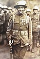 Ludovicus M. M. Van Iersel, 1919
 -
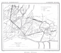 Dussen in 1866
 -
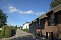 Village view
 -
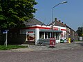 Supermarket


References[edit]
- ^ a b c "Kerncijfers wijken en buurten 2021". Central Bureau of Statistics. Retrieved 14 April 2022.
- ^ "Postcodetool for 4271AA". Actueel Hoogtebestand Nederland (in Dutch). Het Waterschapshuis. Retrieved 14 April 2022.
- ^ "Dussen - (geografische naam)". Etymologiebank (in Dutch). Retrieved 14 April 2022.
- ^ a b Chris Kolman & Ronald Stenvert (1997). Dussen (in Dutch). Zwolle: Waanders. ISBN 90 400 9945 6. Retrieved 14 April 2022.
- ^ a b c "Dussen". Plaatsengids (in Dutch). Retrieved 14 April 2022.
- ^ Ad van der Meer and Onno Boonstra, Repertorium van Nederlandse gemeenten, KNAW, 2011.