
Domoušice
Domoušice | |
|---|---|
 Church of Saint Martin | |
 Flag  Coat of arms | |
 Domoušice Location in the Czech Republic | |
| Coordinates: 50°14′3″N 13°43′47″E / 50.23417°N 13.72972°E | |
| Country | |
| Region | Ústí nad Labem |
| District | Louny |
| First mentioned | 1325 |
| Area | |
| • Total | 15.28 km2 (5.90 sq mi) |
| Elevation | 415 m (1,362 ft) |
| Population (2023-01-01)[1] | |
| • Total | 643 |
| • Density | 42/km2 (110/sq mi) |
| Time zone | UTC+1 (CET) |
| • Summer (DST) | UTC+2 (CEST) |
| Postal codes | 439 68, 440 01 |
| Website | www |
Domoušice (German: Domauschitz) is a municipality and village in Louny District in the Ústí nad Labem Region of the Czech Republic. It has about 600 inhabitants.
Administrative parts[edit]
The village of Solopysky is an administrative part of Domoušice.
Geography[edit]
Pnětluky is located about 14 kilometres (9 mi) southwest of Louny and 46 km (29 mi) northwest of Prague. It lies in the Džbán range. The Hasina stream originates here and flows across the municipality.
The highest point is Pískový vrch at 526 m (1,726 ft) above sea level and the lowest point is the bed of the Hasina stream at 290 m (950 ft).[2]
History[edit]
The area of the gord Na Rovinách was inhabited already in the prehistoric times. The first written mention of Domoušice is from 1325.[3]
Demographics[edit]
|
|
| ||||||||||||||||||||||||||||||||||||||||||||||||||||||
| Source: Censuses[4][5] | ||||||||||||||||||||||||||||||||||||||||||||||||||||||||
Transport[edit]
Domoušice lies on the Rakovník–Most railway line. There are two stations, Domoušice and Solopysky.
Domoušice is connected by two bus lines. A 3rd class road goes through Domoušice.
Sights[edit]
The Church of Saint Martin is a Baroque building from 1754.[6]
The Domoušice Castle is a small rural Baroque mansion from the beginning of the 18th century. Today it is the seat of the forest administration.[7]
Kounov stone series are ancient stone rows, which are often called the most mysterious place in the Czech Republic. They contain about 2,000 quartz stones, most often 80 cm in diameter, and run several hundred metres at irregular intervals from north to south in parallel rows. They are located on a raised plateau in the western part of the municipality and are named after the neighbouring village of Kounov.[8]
Gallery[edit]
-
 Belfry near the church
 -
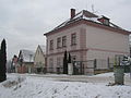 Former school
 -
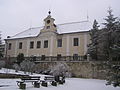 Domoušice Castle
 -
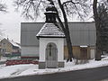 Bell tower with a chapel
 -
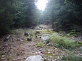 Kounov stone series


References[edit]
- ^ "Population of Municipalities – 1 January 2023". Czech Statistical Office. 2023-05-23.
- ^ "Úvodní strana" (in Czech). Obec Domoušice. Retrieved 2021-07-25.
- ^ "Historie" (in Czech). Obec Domoušice. Retrieved 2021-07-25.
- ^ "Historický lexikon obcí České republiky 1869–2011 – Okres Louny" (in Czech). Czech Statistical Office. 2015-12-21. pp. 1–2.
- ^ "Population Census 2021: Population by sex". Public Database. Czech Statistical Office. 2021-03-27.
- ^ "Kostel sv. Martina" (in Czech). National Heritage Institute. Retrieved 2022-09-07.
- ^ "Zámek" (in Czech). National Heritage Institute. Retrieved 2022-09-07.
- ^ "Expozice Kounovské kamenné řady" (in Czech). CzechTourism. Retrieved 2022-09-07.
External links[edit]
| Authority control databases: National |
|---|