Denshima
Native name: デン島, Denshima | |
|---|---|
 Aerial view of the island. (1978) | |
 | |
| Geography | |
| Location | East China Sea |
| Coordinates | 30°45′02″N 130°06′07″E / 30.75056°N 130.10194°E |
| Archipelago | Ōsumi Islands |
| Highest elevation | 58 m (190 ft) |
| Administration | |
Japan | |
| Prefectures | Kagoshima Prefecture |
| District | Kagoshima District |
| Village | Mishima |
| Demographics | |
| Population | - uninhabited - |
Denshima (デン島), also known as Yuze (湯瀬), is an uninhabited volcanic pillar located in the Ōsumi Islands and belonging to Kagoshima Prefecture, Japan.
Geography[edit]
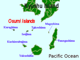
Denshima is located roughly equidistant between Iōjima and Kuroshima. The island is an exposed and highly eroded portion of lava dome associated with the submarine Kikai Caldera, a stratovolcano rising from the ocean floor. It consists of three large rocks, separated by very narrow channels, with a maximum height of 58 metres (190 ft) above sea level, and a smaller rock, just breaching the ocean surface, to one side.
