
Deception Peak
| Deception Peak | |
|---|---|
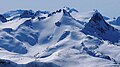
 North aspect, centre (Guard Mountain to right) | |
| Highest point | |
| Elevation | 2,233 m (7,326 ft)[1][2] |
| Prominence | 119 m (390 ft)[1] |
| Parent peak | Castle Towers Mountain[2] |
| Isolation | 1.13 km (0.70 mi)[1] |
| Listing | Mountains of British Columbia |
| Coordinates | 49°54′03″N 122°58′20″W / 49.90083°N 122.97222°W[3] |
| Geography | |
 Deception Peak Location in British Columbia  Deception Peak Deception Peak (Canada) | |
| Country | Canada |
| Province | British Columbia |
| District | New Westminster Land District |
| Protected area | Garibaldi Provincial Park |
| Parent range | Garibaldi Ranges Coast Mountains |
| Topo map | NTS 92G15 Mamquam Mountain[3] |
| Climbing | |
| First ascent | 1922 Neal Carter, Charles Townsend[4] |
Deception Peak is a 2,233-metre (7,326-foot) summit in British Columbia, Canada.
Description[edit]
Deception Peak is located within Garibaldi Provincial Park on the southeast side of Garibaldi Lake,[5] and is part of the Garibaldi Ranges of the Coast Mountains.[1] It is situated 72 km (45 mi) north of Vancouver, 1.51 km (1 mi) west of The Sphinx, and 1.28 km (1 mi) southeast of Guard Mountain.[1] Precipitation runoff from the peak drains to Garibaldi Lake and topographic relief is significant as the summit rises 750 meters (2,460 feet) above the lake in two kilometers (1.2 mile). The mountain was first climbed and named by Neal Carter in 1922.[4] The mountain's toponym was officially adopted on September 2, 1930, by the Geographical Names Board of Canada.[3]
Climate[edit]
Based on the Köppen climate classification, Deception Peak is located in the marine west coast climate zone of western North America.[6] Most weather fronts originate in the Pacific Ocean, and travel east toward the Coast Mountains where they are forced upward by the range (orographic lift), causing them to drop their moisture in the form of rain or snowfall. As a result, the Coast Mountains experience high precipitation, especially during the winter months in the form of snowfall. Winter temperatures can drop below −20 °C with wind chill factors below −30 °C. This climate supports the Sphinx Glacier on the northeast slope of the mountain, the Sentinel Glacier to the south, and the Phoenix Glacier to the southeast.
See also[edit]
Gallery[edit]
-
 Deception Peak centered, northwest aspect.
 -
 Deception Peak (left), Guard Mountain, and Mount Garibaldi (right) from Panorama Ridge
 -
 Deception Peak (left), Guard Mountain, Glacier Pikes, The Table, Mt. Garibaldi, and Mount Price (right) viewed from Panorama Ridge
 -
 Deception Peak (left), Mt. Garibaldi (center), Guard Mountain (right)
 -
 Guard Mountain (centre) with Deception Peak to immediate left


References[edit]
- ^ a b c d e "Deception Peak, British Columbia". Peakbagger.com. Retrieved 2023-03-29.
- ^ a b "Deception Peak, Peakvisor.com". Retrieved 2023-03-29.
- ^ a b c "Deception Peak". Geographical Names Data Base. Natural Resources Canada. Retrieved 2023-03-29.
- ^ a b Neal Carter, Hikeinwhistler.com, Retrieved 2024-03-06.
- ^ "Deception Peak". BC Geographical Names. Retrieved 2023-03-29.
- ^ Peel, M. C.; Finlayson, B. L.; McMahon, T. A. (2007). "Updated world map of the Köppen−Geiger climate classification". Hydrol. Earth Syst. Sci. 11. ISSN 1027-5606.
External links[edit]
- Deception Peak: Weather forecast
Places adjacent to Deception Peak | ||||||||||||||||
|---|---|---|---|---|---|---|---|---|---|---|---|---|---|---|---|---|
| ||||||||||||||||