
Cleveland Crossroads, Alabama
Cleveland Crossroads, Alabama | |
|---|---|
 Cleveland Crossroads, Alabama  Cleveland Crossroads, Alabama | |
| Coordinates: 33°06′47″N 85°59′15″W / 33.11306°N 85.98750°W | |
| Country | United States |
| State | Alabama |
| County | Clay |
| Elevation | 879 ft (268 m) |
| Time zone | UTC-6 (Central (CST)) |
| • Summer (DST) | UTC-5 (CDT) |
| Area code(s) | 256 & 938 |
| GNIS feature ID | 156191[1] |
Cleveland Crossroads, also known as Elias, is an unincorporated community in Clay County, Alabama, United States.
History[edit]
Cleveland Crossroads was originally named Elias in honor of Elias Brantley Cleveland, the first postmaster. After the post office was discontinued, the name was changed to Cleveland Crossroads, also in honor of Elias Cleveland.[2] At one point, Cleveland Crossroads was home to a church, school, mechanic shop, two general stores, and a grist mill.[3] A post office operated under the name Elias from 1886 to 1905.[4]
References[edit]
- ^ "Cleveland Crossroads". Geographic Names Information System. United States Geological Survey, United States Department of the Interior.
- ^ Foscue, Virginia (1989). Place Names in Alabama. Tuscaloosa: The University of Alabama Press. p. 36. ISBN 0-8173-0410-X.
- ^ East, Don. A Historical Analysis of the Creek Indian Hillabee Towns. iUniverse, Inc. pp. 133–5. ISBN 978-1-4401-0163-2.
- ^ "Clay County". Jim Forte Postal History. Retrieved February 28, 2020.
Municipalities and communities of Clay County, Alabama, United States | ||
|---|---|---|
| City | 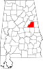 | |
| Town | ||
| CDPs | ||
| Unincorporated communities | ||
This Clay County, Alabama state location article is a stub. You can help Wikipedia by expanding it. |