
Cleveland, Arkansas
Cleveland, Arkansas | |
|---|---|
 Cleveland, Arkansas  Cleveland, Arkansas | |
| Coordinates: 35°25′17″N 92°42′35″W / 35.42139°N 92.70972°W | |
| Country | United States |
| State | Arkansas |
| County | Conway |
| Elevation | 725 ft (221 m) |
| Population (2020) | |
| • Total | 76 |
| Time zone | UTC-6 (Central (CST)) |
| • Summer (DST) | UTC-5 (CDT) |
| ZIP code | 72030 |
| Area code | 501 |
| GNIS feature ID | 76637[1] |
Cleveland is an unincorporated community in Conway County, Arkansas, United States. Cleveland is located on Arkansas Highway 95, 19 miles (31 km) north of Morrilton. Cleveland has a post office with ZIP code 72030.[2] Cleveland was founded in 1890, named after former President Grover Cleveland.
"Downtown" Cleveland consists of the Cleveland Post Office, the Cleveland Corner Store, the Cleveland Volunteer Fire Department, the Cleveland Community Center, and the Cleveland Cemetery, which is the final resting place for a handful of veterans from the American Civil War, as well as 20th century conflicts such as World War I and World War II.[citation needed]
Highway 95, which runs through Cleveland, connects the cities of Morrilton (Conway County) and Clinton (Van Buren County). The Ozark National Forest is nearby.
The main industries in Cleveland are commercial broiler chicken growers for Tyson Foods, cattle husbandry, and natural gas extraction, which is mostly performed by Southwestern Energy, as part of the Fayetteville Shale natural gas deposit.[citation needed]
In September 2023, property at the corner of Hwy 95 and Lentz Rd was fenced off and converted into a town park. The 1st Annual Cleveland Days Festival was held at this site on September 15 and 16 as a fundraiser for the new park.
Education[edit]
Public education for elementary and secondary school students is provided by the Wonderview School District of north Conway County,[3][4] which leads students to graduate from Wonderview High School (which has a Hattieville postal address), 7 miles (11 km) south of Cleveland on Highway 95.
References[edit]
- ^ a b U.S. Geological Survey Geographic Names Information System: Cleveland, Arkansas
- ^ ZIP Code Lookup Archived September 16, 2012, at the Wayback Machine
- ^ "General Highway Map Conway County, Arkansas" (PDF). Arkansas Department of Transportation. Archived from the original (PDF) on July 18, 2011. Retrieved February 27, 2021. – See Cleveland on the map.
- ^ "SCHOOL DISTRICT REFERENCE MAP (2010 CENSUS): Conway County, AR" (PDF). U.S. Census Bureau. Retrieved March 3, 2021. – Compare with the highway map
Municipalities and communities of Conway County, Arkansas, United States | ||
|---|---|---|
| Cities | 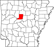 | |
| Town | ||
| CDPs | ||
| Other unincorporated communities | ||
http://www.encyclopediaofarkansas.net/encyclopedia/entry-detail.aspx?entryID=6457