
Claragh Mountain
| Claragh Mountain | |
|---|---|
| Clara Mountain | |
 Clara from the townside | |
| Highest point | |
| Elevation | 452 m (1,483 ft) |
| Listing | Hewitt, Marilyn |
| Coordinates | 52°02′51″N 9°05′37″W / 52.047456°N 9.093642°W |
| Naming | |
| Language of name | Irish |
| Geography | |
 Claragh Mountain | |
| Parent range | Derrynasaggart Mountains |
| OSI/OSNI grid | W328850 |
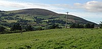
Claragh Mountain or Clara Mountain (Irish:Sléibhe na Clárach) is a 452 metres (1,483 ft) mountain in Millstreet, north-west Cork in Ireland. It is part of the Derrynasaggart Mountain range which spreads across the Cork-Kerry border.[1]
Location and trail[edit]
The foot of the mountain is located 1 km west of Millstreet, the mountain overlooks the town with its cross near the summit. The mountain is very popular to climb and also has a walking trail around the mountain called the Claragh Loop.[2]
Gallery[edit]
-
 Clara mountain on a snowy day
 -
 Clara from the reverse side

