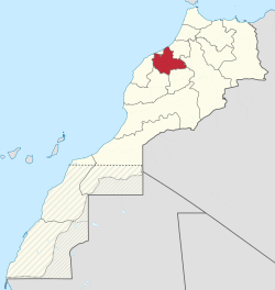
Chaouia-Ouardigha
Chaouia-Ouardigha
الشاوية ورديغة | |
|---|---|
 Location in Morocco (1997–2015) | |
| Coordinates: 33°0′N 7°37′W / 33.000°N 7.617°W | |
| Country | |
| Created | 1997 |
| Abolished | September 2015 |
| Capital | Settat |
| Area | |
| • Total | 7,010 km2 (2,710 sq mi) |
| Population (2014 census) | |
| • Total | 1,893,950 |
| Time zone | UTC+1 (CET) |
Chaouia-Ouardigha (Arabic: الشاوية ورديغة) was formerly one of the sixteen regions of Morocco from 1997 to 2015. It was situated in north-central Morocco in the historical region of Chaouia. It covered an area of 7,010 km² and had a population of 1,893,950 (2014 census).[1] The capital was Settat.
The last Wali (governor) of the region was Mohamed Moufakkir.[2]
Dissolution[edit]
Moroccan regions were reorganized in September 2015: Khouribga Province joined Béni Mellal-Khénifra, while the other three provinces were incorporated into Casablanca-Settat.
Administrative divisions[edit]
The region was made up of the following provinces:
Cities[edit]
References[edit]
- ^ "Recensement général de la population et de l'habitat de 2004" (PDF). Haut-commissariat au Plan, Lavieeco.com. Archived from the original (PDF) on 24 July 2012. Retrieved 22 April 2012.
- ^ "Biographie de M. Mohamed Moufakkir, Wali de la région Chaouia-Ouardigha, gouverneur de la province de Settat". menara.ma. September 30, 2014.
