
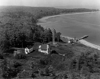
Chambers Island Light
 | |
 | |
| Location | Chambers Island, Wisconsin |
|---|---|
| Coordinates | 45°12′09″N 87°21′53″W / 45.20250°N 87.36472°W |
| Tower | |
| Constructed | 1868 |
| Foundation | Concrete |
| Construction | Brick |
| Automated | 1961 |
| Height | 67 feet (20 m) |
| Shape | Octagonal without lantern |
| Heritage | National Register of Historic Places listed place |
| Light | |
| First lit | 1868 |
| Deactivated | 1961 |
| Focal height | 30 m (98 ft) |
| Range | 10 nmi (19 km; 12 mi) |
| Characteristic | Fl W 6s |
Chambers Island Lighthouse | |
| Area | 40 acres (16 ha) |
| Built | 1868 |
| NRHP reference No. | 75000063[1] |
| Added to NRHP | August 19, 1975 |
The Chambers Island lighthouse is a lighthouse located on Chambers Island in Door County, Wisconsin. It was replaced in 1961 by a skeletal tower, visible for 12 nautical miles (22 km; 14 mi).[2][3] The new light is identified by the USCG as 7-21895.
It was added to the National Register of Historic Places in 1975 as reference #75000063.
-
 USCG archive photo
 -
 USCG archive – no lantern


Notes[edit]
- ^ "National Register Information System". National Register of Historic Places. National Park Service. November 2, 2013.
- ^ Light List, Volume VII, Great Lakes (PDF). Light List. United States Coast Guard. 2014.
- ^ Chambers Island Lighthouse in Lighthouse Resources: Historic Lighthouses & Light Stations, United States Coast Guard, July 22, 2019
Further reading[edit]
- Havighurst, Walter (1943) The Long Ships Passing: The Story of the Great Lakes, Macmillan Publishers.
- Oleszewski, Wes, Great Lakes Lighthouses, American and Canadian: A Comprehensive Directory/Guide to Great Lakes Lighthouses, (Gwinn, Michigan: Avery Color Studios, Inc., 1998) ISBN 0-932212-98-0.
- Pepper, Terry. "Seeing the Light: Lighthouses on the western Great Lakes". Archived from the original on 2022-04-02.
- Sapulski, Wayne S., (2001) Lighthouses of Lake Michigan: Past and Present (Paperback) (Fowlerville: Wilderness Adventure Books) ISBN 0-923568-47-6; ISBN 978-0-923568-47-4.
- Wright, Larry and Wright, Patricia, Great Lakes Lighthouses Encyclopedia Hardback (Erin: Boston Mills Press, 2006) ISBN 1-55046-399-3.
External links[edit]
Wikimedia Commons has media related to Chambers Island Lighthouse.
- Door County Lighthouses, Door County Marine Museum
- Chambers Island Light entry in Seeing the Light (Archived May 9, 2021)
- Lighthouse friends article
- NPS Inventory of Historic Light Stations - Wisconsin (Archived March 14, 2012)
- Rowlett, Russ. "Lighthouses of the United States: Eastern Wisconsin". The Lighthouse Directory. University of North Carolina at Chapel Hill.
- "Historic Light Station Information and Photography: Wisconsin". United States Coast Guard Historian's Office. Archived from the original on 2017-05-01.
- Light List, Volume VII, Great Lakes (PDF). Light List. United States Coast Guard.
- History of the Chambers Island Lighthouse - lists replacement skeletal light

| Topics | |
|---|---|
| Lists by state |
|
| Lists by insular areas | |
| Lists by associated state | |
| Other areas | |
| Related | |
| Authority control databases: Geographic |
|---|