
Calf Creek Falls
.jpg)

Calf Creek Falls refers to a pair of perennial waterfalls on the Calf Creek in the Grand Staircase–Escalante National Monument in central Garfield County, Utah, United States,[1] that total 214 feet (65 m).
Description[edit]
The two tiers of the falls are roughly 2.5 miles (4.0 km) apart. While both tiers are accessible by trail (with both trailheads just off Utah State Route 12), there is no direct access between the tiers.
Lower tier[edit]
Lower Calf Creek Falls[2] is a 126-foot (38 m) cascade and is very popular, because it can be reached by an easy hike on a 5.7-mile (9.2 km) roundtrip trail.[3][4] The lower falls have an elevation of 5,545 feet (1,690 m) and coordinates of 37°49′45″N 111°25′12″W / 37.82917°N 111.42000°W.[2]
Upper tier[edit]
Upper Calf Creek Falls[5] is an 88-foot (27 m) plunge and is much less known, as it requires a 2-mile (3.2 km) roundtrip scramble from the western ridgeline.[6] The lower falls have an elevation of 5,942 feet (1,811 m) and coordinates of 37°51′18″N 111°27′07″W / 37.85500°N 111.45194°W.[5] Just above the upper falls is another smaller, but deep plunge pool (at the base a much smaller cascade) that has a somewhat easier access and is often used for swimming and diving.
Gallery[edit]
-
 Lower Calf Creek Falls Trail, April 2019
 -
 Rock formation with Fremont culture pictograms, April 2019
 -
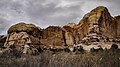
 Rock formation at Lower Calf Creek Falls, April 2019


See also[edit]
References[edit]
- ^ "Lower Calf Creek Falls". visitutah.com. Utah Office of Tourism. Retrieved July 23, 2021.
- ^ a b U.S. Geological Survey Geographic Names Information System: Lower Calf Creek Falls
- ^ "Lower Calf Creek Falls". alltrails.com. Retrieved July 23, 2021.
- ^ "Lower Calf Creek Falls Trail" (PDF). blm.gov. Bureau of Land Management. September 2016. Retrieved July 23, 2021.
- ^ a b U.S. Geological Survey Geographic Names Information System: Upper Calf Creek Falls
- ^ "Upper Calf Creek Falls Trail". alltrails.com. Retrieved July 23, 2021.
External links[edit]
- Lower Calf Creek Falls at worldofwaterfalls.com
- Upper Calf Creek Falls at worldofwaterfalls.com
- Hiking-Calf Creek Falls Lower at utah.com
37°49′45″N 111°25′13″W / 37.82917°N 111.42028°W
This article about a location in Utah is a stub. You can help Wikipedia by expanding it. |