
Burnaby Heights
This article needs additional citations for verification. (August 2013) |

Burnaby Heights, often referred to as The Heights, is a residential neighbourhood in North Burnaby between Boundary Road to the west, Gamma Avenue to the east and bounded by Hastings Street to the south. Its northern edge facing the North Shore Mountains comes down rather steeply to the shores of Burrard Inlet.
Many community events, such as Hats Off Day, Halloween on the Heights and Light up the Heights are held annually.[1] [2][3]
Heritage homes[edit]
Burnaby Heights has a significant number of heritage houses.
-
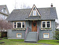
 A heritage house on Cambridge St and MacDonald Ave
 -
 A heritage house on Cambridge St and MacDonald Ave
 -
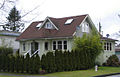
 A heritage house on MacDonald Ave north of Cambridge St
 -
 A heritage house on Cambridge St and MacDonald Ave
 -
 A heritage house on Cambridge St and MacDonald Ave
 -
 A heritage house on Trinity St and Esmond Ave
 -
 A heritage house on Triumph St between Esmond Ave and Boundary Rd
 -
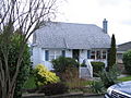 A pre-war house on Trinity St near Ingleton Ave


Christmas on the Heights[edit]
It has become an annual tradition to light up the local stretch of Hastings Street during the Christmas season, which certainly makes it more attractive for shoppers and commuters in this dark time of year. The lights are installed and maintained by the City of Burnaby and light up the heights from November to March each year.
-
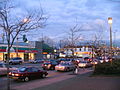 Christmas in the Heights 1
 -
 Christmas in the Heights 2
 -
 Christmas in the Heights 3
 -
 Christmas in the Heights 4


Traffic Issues[edit]
In February 2009, in response to the petitions of various Burnaby heights residents, Burnaby City Council initiated a process to review the traffic issues in the Burnaby Heights neighbourhood.
References[edit]
- ^ "Hats off day". Retrieved August 29, 2013.
- ^ "Halloween on the Heights". Retrieved August 29, 2013.
- ^ "Light up the Heights". Retrieved August 29, 2013.