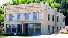
Burkhardt Historic District
Burkhardt Historic District | |
 Chesterfield Airport Rd. | |
| Location | 16662-16678 Chesterfield Airport Rd. (original) and 16626-16660 (even numbered properties only) (boundary increase), Chesterfield, Missouri |
|---|---|
| Coordinates | 38°39′50″N 90°34′45″W / 38.66389°N 90.57917°W |
| Built | 1914 |
| Architectural style | Bungalow/Craftsman, Late Victorian |
| NRHP reference No. | 00001011[1] (original) 06000330 (increase) |
| Significant dates | |
| Added to NRHP | August 31, 2000 |
| Boundary increase | May 5, 2006 |
The Burkhardt Historic District, in Chesterfield, Missouri not far from the Missouri River, was listed on the National Register of Historic Places in 2000, and the listed area was expanded in 2006 to extend further down the south side of Chesterfield Airport Road.[1]

The district consists entirely or mostly of buildings built by or for businessman Edward Burkhardt along what was then known as Olive Street Road (sic) and later became Chesterfield Airport Road. It includes the [Farmers State Bank of Chesterfield (1914), a two-story commercial building which was individually listed on the National Register in 1999. Five buildings were built of structural ceramic tile and brick, which was then a new method of construction. These are two nearly identical Craftsman-style bungalow houses built in 1926 and three garages. And behind one of the bungalows is a small other residence.[2]
The increase added 10 properties, including eight houses and seven outbuildings that are deemed contributing to the historic character of the district, all built within c.1918-c.1925. Most are built with structural ceramic tile and brick construction, and most of the houses were built from standardized plans.[3]
References[edit]
- ^ a b "National Register Information System". National Register of Historic Places. National Park Service. March 13, 2009.
- ^ Debbie Sheals (March 2000). National Register of Historic Places Registration: Burkhardt Historic District / Subdivision of the Lena Burkhardt Estate. National Park Service. Retrieved April 2, 2023. Includes maps and 14 photos from 2000.
- ^ Debbie Sheals (November 2005). National Register of Historic Places Registration: Burkhardt Historic District (Boundary Increase I) / Burkhardt Place. National Park Service. Retrieved April 2, 2023. Includes maps, 12 photos from 2005, and correspondence.


