Bruguers
Bruguers | |
|---|---|
Village | |
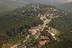
 Aerial view of Bruguers, with the Hermitage near bottom center | |
| Coordinates: 41°18′56.05″N 1°58′03.70″E / 41.3155694°N 1.9676944°E | |
| Country | Spain |
| Autonomous community | Catalonia |
| Province | Barcelona |
| Comarca | Baix Llobregat |
| Municipality | Gavà |
| Elevation | 254 m (833 ft) |
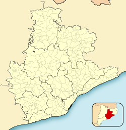
Bruguers is a village within the municipality of Gavà in the comarca of Baix Llobregat, province of Barcelona, Catalonia, Spain. It lies halfway between the towns of Begues and Gavà.[1]
A notable item in Bruguers is the Ermita de Bruguers, also known as the Mare de Déu de Bruguers or Church of Mary at Bruguers. This 13th-century Romanesque church complex contains an effigy of the Virgin Mary from the 14th century.[2][3]
The GR 92 long-distance footpath, which roughly follows the length of the Mediterranean coast of Spain, has a staging point at Bruguers. Stage 20 links northwards to Sant Vicenç dels Horts, a distance of 16.2 kilometres (10.1 mi), whilst stage 21 links southwards to Garraf, a distance of 15.6 kilometres (9.7 mi).[4]
Gallery[edit]
-
The village, with Barcelona city in distance
-
Church of Mary at Bruguers
References[edit]
- ^ Vissir3 (Map). Institut Cartogràfic i Geològic de Catalunya. Retrieved 18 November 2022.
- ^ Josep Campmany (2009): "L’Ermita de la Mare de Déu de Bruguers: breu esbós històric Archived 2017-12-01 at the Wayback Machine". Centre d'Estudis de Gavà (in Catalan), accessed on 2017-11-20
- ^ Goigs a la Mare de Déu de Brugués", accessed on 2019-02-15.
- ^ "GR 92: Sender de la Mediterrània" [GR 92: Mediterranean Path]. www.catalunya.com (in Catalan). Archived from the original on 7 November 2022. Retrieved 7 November 2022.


