
Bozel
Bozel
Bosél (Arpitan) | |
|---|---|
 The church and surrounding buildings in Bozel | |
Location of Bozel  | |
 Bozel  Bozel | |
| Coordinates: 45°27′08″N 6°38′56″E / 45.4522°N 6.6488°E | |
| Country | France |
| Region | Auvergne-Rhône-Alpes |
| Department | Savoie |
| Arrondissement | Albertville |
| Canton | Moûtiers |
| Intercommunality | Val Vanoise |
| Government | |
| • Mayor (2020–2026) | Sylvain Pulcini[1] |
| Area 1 | 28.8 km2 (11.1 sq mi) |
| Population (2021)[2] | 1,949 |
| • Density | 68/km2 (180/sq mi) |
| Time zone | UTC+01:00 (CET) |
| • Summer (DST) | UTC+02:00 (CEST) |
| INSEE/Postal code | 73055 /73350 |
| Elevation | 746–2,589 m (2,448–8,494 ft) (avg. 768 m or 2,520 ft) |
| Website | www.ot-bozel.com, www.bozelinfo.com |
| 1 French Land Register data, which excludes lakes, ponds, glaciers > 1 km2 (0.386 sq mi or 247 acres) and river estuaries. | |
Bozel (French pronunciation: [bɔzɛl]; Arpitan Savoyard: Bosél or Bozél) is a commune in the Savoie department in the Auvergne-Rhône-Alpes region in Southeastern France. In 2019, it had a population of 1,876.
Bozel has one surface ski lift and a green run. It has 19 km of cross-country trails.
In the course of the French Revolution, it was briefly renamed Fructidor.
Gallery[edit]
-
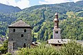 Tour de Bozel and Église Saint-François-de-Sales
 -
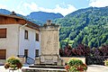 Monument aux morts
.jpg)
.jpg)
See also[edit]
References[edit]
- ^ "Répertoire national des élus: les maires" (in French). data.gouv.fr, Plateforme ouverte des données publiques françaises. 13 September 2022.
- ^ "Populations légales 2021". The National Institute of Statistics and Economic Studies. 28 December 2023.
External links[edit]
Wikimedia Commons has media related to Bozel.
 Bozel travel guide from Wikivoyage
- Official site
| International | |
|---|---|
| National | |
This Savoie geographical article is a stub. You can help Wikipedia by expanding it. |