
Blessum
Blessum | |
|---|---|
Village | |
 Blessum | |
 Location in Menameradiel municipality | |
 Blessum Location in the Netherlands  Blessum Blessum (Netherlands) | |
| Coordinates: 53°10′52″N 5°42′37″E / 53.18111°N 5.71028°E | |
| Country | Netherlands |
| Province | Friesland |
| Municipality | Waadhoeke |
| Area | |
| • Total | 2.65 km2 (1.02 sq mi) |
| Elevation | 0.7 m (2.3 ft) |
| Population (2021)[1] | |
| • Total | 80 |
| • Density | 30/km2 (78/sq mi) |
| Postal code | 9032[1] |
| Dialing code | 058 |
Blessum is a small village in Waadhoeke municipality in the province of Friesland, the Netherlands. It had a population of around 89 in January 2017.[3] Before 2018, the village was part of the Menameradiel municipality.
History[edit]
The village was first mentioned between 1250 and 1275 as Blesingum, and means "settlement of the people of Blesse (person)".[4] Blessum is a terp (artificial living hill) village from the early Middle Ages, and was known to be inhabited in the 9th century. It was located along the former Middelzee, and had a little harbour.[5][6]
The Dutch Reformed church was built by monks around 1250, and was modified in the 15th century. The tower is from the 13th or 14th century and was restored in 1879. Nowadays, it is only used 8 times a year as church, and its main purpose is village house and bed and breakfast.[5][6] The Ringia State was built before 1469 by Doecke Rinia, the local judge. It was demolished in 1823 and replaced by a farm.[7]
Blessum was home to 169 people in 1840.[5] Ironically, Blessum has become more isolated due to the nearby construction of railway lines and motorways,[8] because it is nowadays located at a dead-end road.[5] During World War II, it was home to many onderduikers (people in hiding). There was a constant watch from the church tower and a silent alarm was given when people approached the village.[5]
Gallery[edit]
-
 Interior of the church
 -
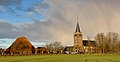 View on Blessum
 -
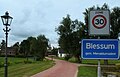 Welcome to Blessum
 -
 Farm in Blessum


.jpg)
References[edit]
- ^ a b c "Kerncijfers wijken en buurten 2021". Central Bureau of Statistics. Retrieved 4 April 2022.
- ^ "Postcodetool for 9032XA". Actueel Hoogtebestand Nederland (in Dutch). Het Waterschapshuis. Retrieved 4 April 2022.
- ^ Aantal inwoners per dorp - Menameradiel
- ^ "Blessum - (geografische naam)". Etymologiebank (in Dutch). Retrieved 4 April 2022.
- ^ a b c d e "Blessum". Plaatsengids (in Dutch). Retrieved 4 April 2022.
- ^ a b Ronald Stenvert & Sabine Broekhoven (2000). "Blessum" (in Dutch). Zwolle: Waanders. ISBN 90 400 9476 4. Retrieved 4 April 2022.
- ^ "Ringia State". Stinsen in Friesland (in Dutch). Retrieved 4 April 2022.
- ^ "Blessum". Friesland Wonderland (in Dutch). Retrieved 4 April 2022.
| Authority control databases: Geographic |
|---|