Białaszewo
Białaszewo | |
|---|---|
Village | |
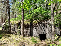
 World War II bunker in Białaszewo | |
| Coordinates: 53°31′N 22°31′E / 53.517°N 22.517°E | |
| Country | |
| Voivodeship | Podlaskie |
| County | Grajewo |
| Gmina | Grajewo |
| Time zone | UTC+1 (CET) |
| • Summer (DST) | UTC+2 (CEST) |
| Vehicle registration | BGR |
Białaszewo [bjawaˈʂɛvɔ] is a village in the administrative district of Gmina Grajewo, within Grajewo County, Podlaskie Voivodeship, in north-eastern Poland.[1] It lies approximately 16 kilometres (10 mi) south of Grajewo and 62 km (39 mi) north-west of the regional capital Białystok.
History[edit]
Białaszewo was a private village of Polish nobility, administratively located in the Masovian Voivodeship in the Greater Poland Province of the Kingdom of Poland. In 1709, a church was erected by Seweryn Szczuka, suffragan bishop of Chełm.[2]
Following the Third Partition of Poland (1795), Białaszewo was annexed by the Prussia. In 1807 it was regained by Poles, and included within the newly established, however short-lived Duchy of Warsaw. Following the duchy's dissolution in 1815, it fell to the Russian Partition of Poland. In 1827 Białaszewo had a population of 121.[2] During the January Uprising, on March 31, 1863, it was the site of a battle between Polish insurgents and Russian troops, during which the Poles were able to retreat with only two casualties.[3] In reprisal, the Russians carried out a massacre of the inhabitants. At least 16 people were killed, including women.[4] After World War I, Poland regained independence and control of the village.
Sights[edit]
There are graves of the fallen insurgents of the January Uprising and the victims of the Russian-perpetrated massacre of 1863,[5] and three World War II bunkers in Białaszewo.
References[edit]
- ^ "Central Statistical Office (GUS) - TERYT (National Register of Territorial Land Apportionment Journal)" (in Polish). 2008-06-01.
- ^ a b Słownik geograficzny Królestwa Polskiego i innych krajów słowiańskich, Tom I (in Polish). Warszawa. 1880. p. 182.
{{cite book}}: CS1 maint: location missing publisher (link) - ^ Zieliński, Stanisław (1913). Bitwy i potyczki 1863-1864. Na podstawie materyałów drukowanych i rękopiśmiennych Muzeum Narodowego w Rapperswilu (in Polish). Rapperswil: Fundusz Wydawniczy Muzeum Narodowego w Rapperswilu. p. 256.
- ^ Katalog miejsc pamięci powstania styczniowego w województwie podlaskim (in Polish). Białystok: Towarzystwo Opieki nad Zabytkami Oddział Białystok. 2013. p. 48.
- ^ Katalog miejsc pamięci powstania styczniowego w województwie podlaskim. pp. 120–121.


