
Barchem
Barchem | |
|---|---|
Village | |
 Church of Barchem | |
 Barchem Location in the Netherlands  Barchem Barchem (Netherlands) | |
| Coordinates: 52°7′27″N 6°26′35″E / 52.12417°N 6.44306°E | |
| Country | Netherlands |
| Province | Gelderland |
| Municipality | Lochem |
| Area | |
| • Total | 25.66 km2 (9.91 sq mi) |
| Elevation | 16 m (52 ft) |
| Population (2021)[1] | |
| • Total | 1,750 |
| • Density | 68/km2 (180/sq mi) |
| Time zone | UTC+1 (CET) |
| • Summer (DST) | UTC+2 (CEST) |
| Postal code | 7244[1] |
| Dialing code | 0573 |
Barchem is a village in the Dutch province of Gelderland, located in the municipality Lochem, about 15 km east of the city of Zutphen.
It was first mentioned in 1474 as Borchem, and means "settlement on/near a hill".[3] It used to be a little agricultural settlement, and used to be centred around the Barchemse Enk.[4]: 1 In 1840, it was home to 346 people.[5] Later, the centre moved to the road from Lochem to Ruurlo where a toll house was constructed in 1857. In 1860, the church was built at the intersection with the road from Borculo to Zwiep. During World War II, Barchem was the scene of heavy fighting.[4]: 1 There are 25 commonwealth graves on the general cemetery.[6]
Gallery[edit]
-
 Art in Barchem
 -
 Free roaming pigs in Barchem
 -
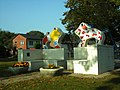
 Commonwealth graves in Barchem


References[edit]
- ^ a b c "Kerncijfers wijken en buurten 2021". Central Bureau of Statistics. Retrieved 22 March 2022.
- ^ "Postcodetool for 7244AA". Actueel Hoogtebestand Nederland (in Dutch). Het Waterschapshuis. Retrieved 22 March 2022.
- ^ "Barchem - (geografische naam)". Etymologiebank (in Dutch). Retrieved 22 March 2022.
- ^ a b "Rondje bijzonder erfgoed in de kern van Barchem" (PDF). HG Lochem (in Dutch). Retrieved 22 March 2022.
- ^ "Barchem". Plaatsengids (in Dutch). Retrieved 22 March 2022.
- ^ "Laren (Barchem) General Cemetery". Commonwealth Graves Cemeteries (in Dutch). Retrieved 22 March 2022.
This Gelderland location article is a stub. You can help Wikipedia by expanding it. |