Ballinamuck
Ballinamuck
Béal Átha na Muc | |
|---|---|
Village | |
 Pikemen memorial in Ballinamuck | |
| Motto: Is glas iad na cnoic i bhfad uainn / The faraway hills are green. | |
| Coordinates: 53°52′00″N 7°43′00″W / 53.866667°N 7.716667°W | |
| Country | Ireland |
| Province | Leinster |
| County | County Longford |
| Elevation | 82 m (269 ft) |
| Time zone | UTC+0 (WET) |
| • Summer (DST) | UTC-1 (IST (WEST)) |
| Irish Grid Reference | N184907 |
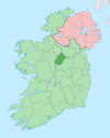
Ballinamuck (Irish: Béal Átha na Muc, meaning "mouth of the pig's ford")[1] is a village in north County Longford, Ireland. It is around 15 km north of Longford town.
It was the scene of the Battle of Ballinamuck, where a French army aiding the United Irishmen rebellion of 1798 was defeated. The French soldiers were eventually repatriated. The Irish prisoners were taken to St Johnstown - today's Ballinalee - where they were executed in what is known locally as Bullys Acre and buried there. Ballinamuck is twinned with the French town of Essert.
Transport[edit]
Whartons Travel operates bus route 975 on behalf of the National Transport Authority. It serves the village six times a day (not Sundays) providing services to Longford via Drumlish and to Cavan via Arva.[2][3] Bus Éireann route 463 (Carrigallen-Longford) serves the village on Wednesdays. The nearest rail services can be accessed at Longford railway station.
References[edit]
- ^ "Béal Átha na Muc/Ballinamuck". Placenames Database of Ireland (logainm.ie). Retrieved 8 October 2021.
- ^ "Route 975 Cavan – Arvagh- Longford Bus Service Commences". nationaltransport.ie. Archived from the original on 18 December 2017. Retrieved 7 August 2014.
- ^ "Longford Bus - Route 975 Timetable". whartonstravel.com. Archived from the original on 22 December 2015. Retrieved 19 December 2015.


