
Altels
| Altels | |
|---|---|
 Western face of the Altels | |
| Highest point | |
| Elevation | 3,630 m (11,910 ft) |
| Prominence | 100 m (330 ft)[1] |
| Parent peak | Balmhorn |
| Isolation | 0.92 km (0.57 mi) |
| Coordinates | 46°25′43.72″N 07°40′42″E / 46.4288111°N 7.67833°E |
| Geography | |
 Altels Location in Switzerland | |
| Location | Bern/Valais Switzerland |
| Parent range | Bernese Alps |
The Altels (3,630 m) is a mountain of the Bernese Alps, located on the border between the Swiss cantons of Bern and Valais. It is situated in the Balmhorn massif, approximately halfway between Kandersteg and Leukerbad.
Although its south side is in Valais, the mountain lies within the Aar basin.
-
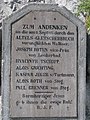 Altels memorial
 -
 Seen from the Sunbüel

.jpg)
References[edit]
External links[edit]
Wikimedia Commons has media related to Altels.
This Canton of Bern location article is a stub. You can help Wikipedia by expanding it. |
This Valais location article is a stub. You can help Wikipedia by expanding it. |