
Aguada barrio-pueblo
Aguada barrio-pueblo
Pueblo de Aguada | |
|---|---|
Municipality Seat[1] | |
 Aguada City Hall | |
 Location of Tejas within the municipality of Aguada shown in red | |
 Aguada barrio-pueblo Location of Puerto Rico | |
| Coordinates: 18°22′49″N 67°11′19″W / 18.380211°N 67.188632°W[2] | |
| Commonwealth | |
| Municipality | |
| Area | |
| • Total | 0.11 sq mi (0.3 km2) |
| • Land | 0.11 sq mi (0.3 km2) |
| • Water | 0.00 sq mi (0.0 km2) |
| Elevation | 59 ft (18 m) |
| Population (2010) | |
| • Total | 1,324 |
| • Density | 12,036.4/sq mi (4,647.3/km2) |
| Source: 2010 Census | |
| Time zone | UTC−4 (AST) |
| ZIP Code | 00602 |
| Area code(s) | 787, 939 |
Aguada barrio-pueblo is a small barrio and the administrative center (seat) of Aguada, a municipality of Puerto Rico. Its population in 2010 was 1,324. Aguada barrio-pueblo has two subdivisions: California and Rosario.[1][4][5][6]
As was customary in Spain, in Puerto Rico, the municipality has a barrio called pueblo which contains a central plaza, the municipal buildings (city hall), and a Catholic church. Fiestas patronales (patron saint festivals) are held in the central plaza every year.[7][8]
The central plaza and its church[edit]
The central plaza, or square, is a place for official and unofficial recreational events and a place where people can gather and socialize from dusk to dawn. The Laws of the Indies, Spanish law, which regulated life in Puerto Rico in the early 19th century, stated the plaza's purpose was for "the parties" (celebrations, festivities) (Spanish: a propósito para las fiestas), and that the square should be proportionally large enough for the number of neighbors (Spanish: grandeza proporcionada al número de vecinos). These Spanish regulations also stated that the streets nearby should be comfortable portals for passersby, protecting them from the elements: sun and rain.[7]
In 1516, the Ermita de Espinar church was built, and after it was destroyed by indigenous people, it was reconstructed in 1639.
Located across the central plaza in Aguada barrio-pueblo is the Parroquia San Francisco de Asís, a Roman Catholic church. It was built in 1692, then reconstructed in 1793. It was destroyed by the 1918 San Fermín earthquake. Following the architectural design of Antonio Martínez and José Lazaro, it was rebuilt between the years 1924 and 1936. Stained glass windows were installed in 1956 and again in 1964. Its interior was remodeled in 1993.[9]
The oldest festival in Puerto Rico was celebrated in and around the church in Aguada. To honor the Immaculate Conception it was held for many years, starting in the 16th century. The festival which lasted eight days went on for many years until ended by the church for having become too commercialized.[10]
Aguada's annual patron saint festival in honor of Francis of Assisi is held from late September to early October in the Plaza Carlos Ruiz.[10]
| Census | Pop. | Note | %± |
|---|---|---|---|
| 1910 | 909 | — | |
| 1920 | 1,078 | 18.6% | |
| 1930 | 1,662 | 54.2% | |
| 1940 | 2,137 | 28.6% | |
| 1950 | 3,178 | 48.7% | |
| 1960 | 3,759 | 18.3% | |
| 1970 | 0 | −100.0% | |
| 1980 | 2,130 | — | |
| 1990 | 1,826 | −14.3% | |
| 2000 | 1,755 | −3.9% | |
| 2010 | 1,324 | −24.6% | |
| U.S. Decennial Census 1900 (N/A)[11] 1910-1930[12] 1930-1950[13] 1960[14] 1980-2000[15] 2010[16] | |||
Sectors[edit]
Barrios (which are like minor civil divisions)[6] in turn are further subdivided into smaller local populated place areas/units called sectores (sectors in English). The types of sectores may vary, from normally sector to urbanización to reparto to barriada to residencial, among others.
The following sectores are in Aguada barrio-pueblo:[17]
Calle Elomita, Calle Paz, Este De La Calle Manuel Ruíz González, Hogar Love and Care, Oeste De La Calle Manuel Ruíz González, Residencias de Colores, Ruíz González, Sector California, Sector Rosario, Urbanización Moropó, and Urbanización San Cristóbal.
In Aguada barrio-pueblo is part of the Aguada urban zone.[1]
Gallery[edit]
Places in Aguada barrio-pueblo:
-
 A statue of Cristóbal Colón in the plaza
 -
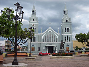 The main plaza and the Roman Catholic Church of Aguada
 -
 Parroquia de San Francisco de Asís


See also[edit]
References[edit]
- ^ a b c Puerto Rico: 2010 Population and Housing Unit Counts.pdf (PDF). U.S. Dept. of Commerce, Economics and Statistics Administration, U.S. Census Bureau. 2010.
- ^ a b "US Gazetteer 2019". US Census. US Government.
- ^ U.S. Geological Survey Geographic Names Information System: Aguada Barrio-Pueblo
- ^ Picó, Rafael; Buitrago de Santiago, Zayda; Berrios, Hector H. Nueva geografía de Puerto Rico: física, económica, y social, por Rafael Picó. Con la colaboración de Zayda Buitrago de Santiago y Héctor H. Berrios (in Spanish). San Juan Editorial Universitaria, Universidad de Puerto Rico,1969.
- ^ Gwillim Law (20 May 2015). Administrative Subdivisions of Countries: A Comprehensive World Reference, 1900 through 1998. McFarland. p. 300. ISBN 978-1-4766-0447-3. Retrieved 25 December 2018.
- ^ a b "US Census Barrio-Pueblo definition". factfinder.com. US Census. Archived from the original on 13 May 2017. Retrieved 5 January 2019.
- ^ a b Santullano, Luis A. (10 March 2019). Mirada al Caribe. Vol. 54. Colegio de Mexico. pp. 75–78. doi:10.2307/j.ctvbcd2vs.12. JSTOR j.ctvbcd2vs.12.
- ^ Pariser, Harry S. (2003). Explore Puerto Rico, Fifth Edition. San Francisco: Manatee Press. pp. 52–55. Retrieved 10 February 2019.
- ^ Mari Mut, José A. (2013-08-28). Los Pueblos de Puerto Rico y Las Iglesias de Sus Plazas [The Pueblos of Puerto Rico, and the Churches of its Plazas] (PDF) (in Spanish). pp. 13–15. Retrieved 2020-12-14.
- ^ a b "AGUADA - ¡LA VILLA DE SOTOMAYOR!" (PDF). aguada.gov.pr. Government of Aguada, Puerto Rico. p. 9. Retrieved 21 January 2022.
- ^ "Report of the Census of Porto Rico 1899". War Department Office Director Census of Porto Rico. Archived from the original on July 16, 2017. Retrieved September 21, 2017.
- ^ "Table 3-Population of Municipalities: 1930 1920 and 1910" (PDF). United States Census Bureau. Archived (PDF) from the original on August 17, 2017. Retrieved September 21, 2017.
- ^ "Table 4-Area and Population of Municipalities Urban and Rural: 1930 to 1950" (PDF). United States Census Bureau. Archived (PDF) from the original on August 30, 2015. Retrieved September 21, 2014.
- ^ Census of Population, 1960: Number of Inhabitants, General Population Characteristics, General Social and Economic Characteristics, and Detailed Characteristics. Characteristics of the population. U.S. Bureau of the Census. 1963. pp. 97–101. Retrieved June 10, 2023.
- ^ "Table 2 Population and Housing Units: 1960 to 2000" (PDF). United States Census Bureau. Archived (PDF) from the original on July 24, 2017. Retrieved September 21, 2017.
- ^ Puerto Rico: 2010 Population and Housing Unit Counts.pdf (PDF). U.S. Dept. of Commerce Economics and Statistics Administration U.S. Census Bureau. 2010. Archived (PDF) from the original on 2017-02-20. Retrieved 2019-08-02.
- ^ "DESGLOSE DE SECTORES Y CENTROS DE VOTACIÓN PRECINTO ELECTORAL - AGUADA 038" (PDF). Comisión Estatal de Elecciones Puerto Rico (in Spanish). 28 October 2019. Archived from the original (PDF) on 16 June 2020. Retrieved 16 June 2020.