
Aduarderzijl
Aduarderzijl
Auwerderziel (Gronings) | |
|---|---|
 Entrance to Aduarderzijl | |
 Aduarderzijl Location in the province of Groningen in the Netherlands  Aduarderzijl Aduarderzijl (Netherlands) | |
| Coordinates: 53°19′08″N 6°28′01″E / 53.31877°N 6.46705°E | |
| Country | |
| Province | |
| Municipality | |
| Village | Feerwerd |
| Elevation | 1.0 m (3.3 ft) |
| Population | |
| • Total | c. 50 |
| Time zone | UTC+1 (CET) |
| • Summer (DST) | UTC+2 (CEST) |
| Postcode | 9892 |
| Area code | 0594 |
Aduarderzijl (Dutch pronunciation: [ˌaː.dyˌɑr.dərˈzɛi̯l]; Gronings: Auwerderziel is a hamlet in the municipality of Westerkwartier in the province of Groningen in the Netherlands, located to the south of the Reitdiep. Administratively, it is part of the village of Feerwerd.
The hamlet is located east of the hamlet of Allersma, northeast of the village of Ezinge, north of the village of Feerwerd, and northwest of the wierde of Antum and the village of Garnwerd. The hamlet is home to the lock complex of the same name, the Aduarderzijlen. This complex near the Reitdiep consists of restored locks from 1706 and 1867.
Gallery[edit]
-
 't Waarhuis
 -
 Aduarderzijl seen from the Kokersluis with 't Waarhuis behind it on the right
 -
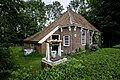 Former worker's house
 -
 Rate list


References[edit]
- ^ "Postcodetool for 9892TE". Actueel Hoogtebestand Nederland (in Dutch). Het Waterschapshuis. Retrieved 1 September 2023.
External links[edit]
![]() Media related to Aduarderzijl at Wikimedia Commons
Media related to Aduarderzijl at Wikimedia Commons
This Groningen location article is a stub. You can help Wikipedia by expanding it. |