
Portal:Myanmar
ကြိုဆိုပါတယ်။ / Welcome to the Myanmar Portal 

Myanmar, officially the Republic of the Union of Myanmar and also known as Burma (the official name until 1989), is a country in Southeast Asia. It is the largest country by area in Mainland Southeast Asia and has a population of about 55 million. It is bordered by Bangladesh and India to its northwest, China to its northeast, Laos and Thailand to its east and southeast, and the Andaman Sea and the Bay of Bengal to its south and southwest. The country's capital city is Naypyidaw, and its largest city is Yangon (formerly Rangoon).
Myanmar is a member of the East Asia Summit, Non-Aligned Movement, ASEAN, and BIMSTEC, but it is not a member of the Commonwealth of Nations despite once being part of the British Empire. Myanmar is a Dialogue Partner of the Shanghai Cooperation Organization. The country is very rich in natural resources, such as jade, gems, oil, natural gas, teak and other minerals, as well as also endowed with renewable energy, having the highest solar power potential compared to other countries of the Great Mekong Subregion. However, Myanmar has long suffered from instability, factional violence, corruption, poor infrastructure, as well as a long history of colonial exploitation with little regard to human development. In 2013, its GDP (nominal) stood at US$56.7 billion and its GDP (PPP) at US$221.5 billion. The income gap in Myanmar is among the widest in the world, as a large proportion of the economy is controlled by cronies of the military junta. Myanmar is one of the least developed countries; as of 2020, according to the Human Development Index, it ranks 147 out of 189 countries in terms of human development, the lowest in Southeast Asia. Since 2021, more than 600,000 people were displaced across Myanmar due to the surge in violence post-coup, with more than 3 million people in dire need of humanitarian assistance. (Full article...)
Selected articles -
-
![Image 1 Dein Mani-Yut (Mon: ဒိန်ၝိတ်ရတ်; Burmese: ဒိန်မဏိရွတ်, Burmese pronunciation: [dèiɴ mənḭ jʊ̯ʔ]), commonly known as Amat Dein (အမတ်ဒိန်, "Minister Dein") or as Amat Tein (အမတ်တိန်, "Minister Tein"), was co-chief minister of Hanthawaddy during the reign of King Razadarit (1384–1421). He was also a senior general, and held key governorship posts at Syriam (1370s–1408), Bassein (1408–1415) and Sittaung (1415–1420s). Along with his colleague Byat Za, Dein was instrumental in Razadarit's reunification campaigns of the Mon-speaking kingdom in the late 1380s, as well as the Forty Years' War against the Burmese-speaking Ava Kingdom. (Full article...)](//upload.wikimedia.org/wikipedia/en/d/d2/Blank.png) Dein Mani-Yut (Mon: ဒိန်ၝိတ်ရတ်; Burmese: ဒိန်မဏိရွတ်, Burmese pronunciation: [dèiɴ mənḭ jʊ̯ʔ]), commonly known as Amat Dein (အမတ်ဒိန်, "Minister Dein") or as Amat Tein (အမတ်တိန်, "Minister Tein"), was co-chief minister of Hanthawaddy during the reign of King Razadarit (1384–1421). He was also a senior general, and held key governorship posts at Syriam (1370s–1408), Bassein (1408–1415) and Sittaung (1415–1420s). Along with his colleague Byat Za, Dein was instrumental in Razadarit's reunification campaigns of the Mon-speaking kingdom in the late 1380s, as well as the Forty Years' War against the Burmese-speaking Ava Kingdom. (Full article...)
Dein Mani-Yut (Mon: ဒိန်ၝိတ်ရတ်; Burmese: ဒိန်မဏိရွတ်, Burmese pronunciation: [dèiɴ mənḭ jʊ̯ʔ]), commonly known as Amat Dein (အမတ်ဒိန်, "Minister Dein") or as Amat Tein (အမတ်တိန်, "Minister Tein"), was co-chief minister of Hanthawaddy during the reign of King Razadarit (1384–1421). He was also a senior general, and held key governorship posts at Syriam (1370s–1408), Bassein (1408–1415) and Sittaung (1415–1420s). Along with his colleague Byat Za, Dein was instrumental in Razadarit's reunification campaigns of the Mon-speaking kingdom in the late 1380s, as well as the Forty Years' War against the Burmese-speaking Ava Kingdom. (Full article...) -
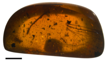
Wing of the dragonfly Burmalindenia in a cabochon of Burmese amber, showing typical red colouration of the amber. Scale bar = 5mm
Burmese amber, also known as Burmite or Kachin amber, is amber from the Hukawng Valley in northern Myanmar. The amber is dated to around 100 million years ago, during the latest Albian to earliest Cenomanian ages of the mid-Cretaceous period. The amber is of significant palaeontological interest due to the diversity of flora and fauna contained as inclusions, particularly arthropods including insects and arachnids but also birds, lizards, snakes, frogs and fragmentary dinosaur remains. The amber has been known and commercially exploited since the first century AD, and has been known to science since the mid-nineteenth century. Research on the deposit has attracted controversy due to its alleged role in funding internal conflict in Myanmar and hazardous working conditions in the mines where it is collected. (Full article...) -
The Salween is a Southeast Asian river, about 3,289 kilometres (2,044 mi) long, flowing from the Tibetan Plateau south into the Andaman Sea. The Salween flows primarily within southwest China and eastern Myanmar (Burma), with a short section forming the border of Burma and Thailand. Throughout most of its course, it runs swiftly through rugged mountain canyons. Despite the river's great length, only the last 90 km (56 mi) are navigable, where it forms a modest estuary and delta at Mawlamyine. The river is known by various names along its course, including the Thanlwin (named after Elaeocarpus sp., an olive-like plant that grows on its banks) in Burma and the Nu Jiang (or Nu River, named after Nu people) in China. The commonly used spelling "Salween" is an anglicisation of the Burmese name dating from 19th-century British maps.
Due to its great range of elevation and latitude coupled with geographic isolation, the Salween basin is considered one of the most ecologically diverse regions in the world, containing an estimated 25 percent of the world's terrestrial animal species and thousands of plant species. Along its course the Salween provides water for agriculture and supports abundant fisheries, especially in the delta region. The Salween basin is home to numerous ethnic minority groups, whose ancestors largely originated in the Tibetan Plateau and northwest China. Starting about 5,000 years ago, people began migrating south along the river, establishing small kingdoms and city-states. (Full article...) -

Myanmar (Burma) and North Korea established bilateral diplomatic relations in May 1975. The history of contacts between the two countries goes back to 1948, the year of the declaration of Burmese independence. Initially, however, Burma under U Nu favored Syngman Rhee's government in the south of Korea. During and after the Korean War, Burma balanced the interest of North and South Korea, taking into consideration the position of China. After the 1975 establishment of diplomatic relations Burma began to shift toward North Korea, which was also nominally socialist and equally wary of Western imperialism.
The Rangoon bombing on 9 October 1983 was a turning point in Myanmar–North Korea relations. Once it found out that North Koreans were behind the attack, Myanmar cut off diplomatic relations and went as far as withdrawing formal recognition of the country. Relations began to recover during the years of the Sunshine Policy when South Korea encouraged the North's rapprochement with Myanmar. Strategic considerations brought Myanmar and North Korea even closer. Myanmar had natural resources that North Korea needed, and North Korea began supplying Myanmar with military technology. Diplomatic relations were restored on 25 April 2007. (Full article...) -
The first Mongol invasions of Burma (Burmese: မွန်ဂို–မြန်မာ စစ် (၁၂၇၇–၁၂၈၇); Chinese: 元緬戰爭) were a series of military conflicts between Kublai Khan's Yuan dynasty, a division of the Mongol Empire, and the Pagan Empire that took place between 1277 and 1287. The invasions toppled the 250-year-old Pagan Empire, and the Mongol army seized Pagan territories in present-day Dehong, Yunnan and northern Burma to Tagaung. The invasions ushered in 250 years of political fragmentation in Burma and the rise of ethnic Tai-Shan states throughout mainland Southeast Asia.
The Mongols first demanded tribute from Pagan in 1271–72, as part of their drive to encircle the Song dynasty of China. When King Narathihapate refused, Emperor Kublai Khan himself sent another mission in 1273, again demanding tribute. It too was rejected. In 1275, the emperor ordered the Yunnan government to secure the borderlands in order to block an escape path for the Song, and permitted a limited border war if Pagan contested. Pagan did contest but its army was driven back at the frontier by the Mongol Army in 1277–78. After a brief lull, Kublai Khan in 1281 turned his attention to Southeast Asia, demanding tribute from Pagan, the Khmer Empire, Đại Việt and Champa. When the Burmese king again refused, the emperor ordered an invasion of northern Burma. Two dry season campaigns (1283–1285) later, the Mongols had occupied down to Tagaung and Hanlin, forcing the Burmese king to flee to Lower Burma. The Mongols organized northern Burma as the province of Zhengmian. (Full article...) -
The Bay of Bengal is the northeastern part of the Indian Ocean. The world's largest bay, geographically it is positioned between the Indian subcontinent and the Indochinese peninsula, located below the Bengal region (based on which the bay was named during the British Raj).
Many South Asian and Southeast Asian countries are dependent on the Bay of Bengal. Geopolitically, the bay is bounded on the west and northwest by India, on the north by Bangladesh, and on the east by Myanmar and the Andaman and Nicobar Islands of India. Its southern limit is a line between Sangaman Kanda, Sri Lanka, and the northwesternmost point of Sumatra, Indonesia. Cox's Bazar, the longest sea beach in the world and Sundarbans, the largest mangrove forest and the natural habitat of the Bengal tiger, are located along the bay. (Full article...) -

U Thaw (Burmese: ဦးသော်; 5 September 1893 – 25 June 1980), known honorifically as Baganset U Thaw (Burmese: ပန်းကန်စက် ဦးသော်), was a Burmese businessman, trader, administrator, and politician. He was the first manufacturer of porcelain products in Burma. He was a member of the Legislative Council of Burma, patron of the Young Men's Buddhist Association (YMBA), chairman of Myoma National High School Administration Board, and one of the leaders of the General Council of Burmese Associations. (Full article...) -

Yangon Circular Railway (Burmese: ရန်ကုန် မြို့ပတ် ရထား [jàɰ̃ɡòʊɰ̃ mjo̰baʔ jətʰá]) is the local commuter rail network that serves the Yangon metropolitan area. Operated by Myanma Railways, the 45.9-kilometre (28.5 mi) 39-station loop system connects satellite towns and suburban areas to the city. Circa 2008–2010, the railway had about 200 coaches, had 20 daily runs, and sold 100,000 to 150,000 tickets daily.
The railway is heavily utilized by lower-income commuters, as it is (along with buses) the cheapest method of transportation in Yangon.
The hours of service have been consistent over the years, from 3:45 am to 10:15 pm daily. In 2011, the cost of a ticket for a distance of 15 miles was two hundred kyats (~eighteen US cents), and that for over 15 miles was four hundred kyats (~37 US cents). In the new currency (introduced in 2012) long distance tickets are 200 kyat (~20 US cents). (Full article...) -

The State Peace and Development Council (Burmese: နိုင်ငံတော် အေးချမ်းသာယာရေး နှင့် ဖွံ့ဖြိုးရေး ကောင်စီ [nàɪɰ̃ŋàɰ̃dɔ̀ ʔédʑáɰ̃θàjajé n̥ḭɰ̃ pʰʊ̰ɰ̃bjó jé kaʊ̀ɰ̃sì]; abbreviated SPDC or နအဖ, [na̰ʔa̰pʰa̰]) was the official name of the military government of Burma (Myanmar) which, in 1997, succeeded the State Law and Order Restoration Council (Burmese: နိုင်ငံတော် ငြိမ်ဝပ်ပိပြားမှု တည်ဆောက်ရေးအဖွဲ့; abbreviated SLORC or နဝတ) that had seized power under the rule of Saw Maung in 1988. On 30 March 2011, Senior General and Council Chairman Than Shwe signed a decree that officially dissolved the council.
SLORC succeeded the Pyithu Hluttaw as a legislature and the Council of State as a ruling council, after dissolving the state organs of the Socialist Republic of the Union of Burma. In 1997, SLORC was abolished and reconstituted as the State Peace and Development Council (SPDC). The powerful regional military commanders, who were members of SLORC, were promoted to new positions and transferred to the capital of Rangoon (now Yangon). The new regional military commanders were not included in the membership of the SPDC. (Full article...) -
The Karen conflict is an armed conflict in Kayin State, Myanmar (formerly known as Karen State, Burma). It is part of the wider internal conflict in Myanmar between the military government and various minority groups. Karen nationalists have been fighting for an independent state, known as Kawthoolei, since 1949. The Karen National Union (KNU) and its Karen National Liberation Army (KNLA) are the most prominent Karen rebel groups. Hundreds of thousands of civilians have been displaced by the conflict, many of whom fled to neighbouring Thailand and survive in refugee camps.
Tensions between the Karen people and the Bamar ethnic majority in Myanmar have existed since colonial-era based on the British 'direct and indirect rule' policy and Karen soldiers' roles in putting down Burmese rebellions in the late 19th century. Around the time of Burmese independence, the Karen National Defence Organisation (KNDO) was formed as an armed wing of the Karen National Union (KNU) to put down a communist rebellion. After the Burmese government settled for peace and allowed communist back into national politics, a series of tensions, escalations and battles led to the KNU declaring formally war on the Burmese government on 31 January 1949. (Full article...)
![Image 1 Dein Mani-Yut (Mon: ဒိန်ၝိတ်ရတ်; Burmese: ဒိန်မဏိရွတ်, Burmese pronunciation: [dèiɴ mənḭ jʊ̯ʔ]), commonly known as Amat Dein (အမတ်ဒိန်, "Minister Dein") or as Amat Tein (အမတ်တိန်, "Minister Tein"), was co-chief minister of Hanthawaddy during the reign of King Razadarit (1384–1421). He was also a senior general, and held key governorship posts at Syriam (1370s–1408), Bassein (1408–1415) and Sittaung (1415–1420s). Along with his colleague Byat Za, Dein was instrumental in Razadarit's reunification campaigns of the Mon-speaking kingdom in the late 1380s, as well as the Forty Years' War against the Burmese-speaking Ava Kingdom. (Full article...)](/wiki/File:Blank.png)


.png)


.svg)
.jpg)
Did you know (auto-generated) -

- ... that Rolling Stone named Mission of Burma's "Academy Fight Song" as one of the 100 greatest debut singles of all time?
- ... that Aung Myo Min, Union Minister of Human Rights for the National Unity Government of Myanmar, is the country's first openly LGBT minister?
- ... that as part of the coronation of Mindon Min, the square yuzana around the capital was designated a sanctuary?
- ... that the mission of the United Nations special envoy on Myanmar has been called a "diplomatic graveyard"?
- ... that clashes between the Myanmar military and local armed groups broke out in Lay Kay Kaw six years after it was established as a "town of peace" between the parties?
- ... that Maw Htun Aung, a Shan Nationalities League for Democracy candidate in the 2020 Myanmar general election, is Kachin, not Shan?
- ... that Rangoon kept its own time for more than two decades after Burma Standard Time first came into effect?
- ... that the Burmese Buddhist monk Sagyo Thu-Myat successfully lobbied for the recalibration of the Burmese calendar?
Related portals and projects
General images -
-
 Salween river at Mae Sam Laep on the Thai-Myanmar border (from Geography of Myanmar)
 -
 British soldiers dismantling cannons belonging to King Thibaw's forces, Third Anglo-Burmese War, Ava, 27 November 1885. Photographer: Hooper, Willoughby Wallace (1837–1912). (from History of Myanmar)
 -
 Temples at Mrauk U, was the capital of the Mrauk U Kingdom, which ruled over what is now Rakhine State. (from History of Myanmar)
 -
 Political Map of Burma (Myanmar) c. 1450 CE. (from History of Myanmar)
 -
 The shores of Irrawaddy River at Nyaung-U, Bagan (from Geography of Myanmar)
 -
 A group of Buddhist worshipers at Shwedagon Pagoda, an important religious site for Burmese Buddhists (from Culture of Myanmar)
 -
 Aerial view of a burned Rohingya village in Rakhine state, Myanmar, September 2017 (from History of Myanmar)
 -
 19th-century funeral cart and spire, which would form part of the procession from the home to the place of cremation (from Culture of Myanmar)
 -
 Pagan Kingdom during Narapatisithu's reign. Burmese chronicles also claim Kengtung and Chiang Mai. Core areas shown in darker yellow. Peripheral areas in light yellow. Pagan incorporated key ports of Lower Burma into its core administration by the 13th century. (from History of Myanmar)
 -
 A wide range of Burmese lacquerware from Bagan (from Culture of Myanmar)
 -
 Jade Mine in Hpakant (from Geography of Myanmar)
 -
 A bull fight, 19th-century watercolour (from Culture of Myanmar)
 -
 Portuguese ruler and soldiers mounting an Elephant. Philips, Jan Caspar (draughtsman and engraver) (from History of Myanmar)
 -
 Two female musicians play the saung at a performance in Mandalay. (from Culture of Myanmar)
 -
 Sculpture of Myanmar mythical lion (from Culture of Myanmar)
 -
 Mountains near Pindaya on the Shan Plateau (from Geography of Myanmar)
 -
 Mount Popa, a dormant volcano in the Central Lowlands (from Geography of Myanmar)
 -
 British soldiers on patrol in the ruins of the Burmese town of Bahe during the advance on Mandalay, January 1945. (from History of Myanmar)
 -
 Hlei pyaingbwè - a Burmese regatta (from Culture of Myanmar)
 -
 Boxing match, 19th-century watercolour (from Culture of Myanmar)
 -
 British soldiers remove their shoes at the entrance of Shwedagon Pagoda. To the left, a sign reads "Foot wearing is strictly prohibited" in Burmese, English, Tamil, and Urdu. (from Culture of Myanmar)
 -
 A wedding procession, with the groom and bride dressed in traditional Burmese wedding clothes, reminiscent of royal attire (from Culture of Myanmar)
 -
 Recorder's Court on Sule Pagoda Road, with the Sule Pagoda at the far end, Rangoon, 1868. Photographer: J. Jackson. (from History of Myanmar)
 -
 Myanmar (Burma) map of Köppen climate classification (from Geography of Myanmar)
 -
 A theatrical performance of the Mon dance (from Culture of Myanmar)
 -
 Saint Mary's Cathedral in Downtown Yangon is the largest Roman Catholic cathedral in Burma. (from Culture of Myanmar)
 -

-
 Protesters in Yangon carrying signs reading "Free Daw Aung San Suu Kyi" on 8 February 2021. (from History of Myanmar)
 -
 Former US President Barack Obama poses barefoot on the grounds of Shwedagon Pagoda, one of Myanmar's major Buddhist pilgrimage sites. (from Culture of Myanmar)
 -
 Protesters in Yangon with a banner that reads non-violence: national movement in Burmese, in the background is Shwedagon Pagoda. (from History of Myanmar)
 -
 The paddle steamer Ramapoora (right) of the British India Steam Navigation Company on the Rangoon river having just arrived from Moulmein. 1895. Photographers: Watts and Skeen (from History of Myanmar)
 -

-
 Grandfather Island, Dawei (from Geography of Myanmar)
 -

-
 Aung San Suu Kyi addresses crowds at the NLD headquarters shortly after her release. (from History of Myanmar)
 -
 Myinhkin thabin - equestrian sport (from Culture of Myanmar)
 -
 The restored Taungoo or Nyaungyan dynasty c. 1650 CE. (from History of Myanmar)
 -
 Vegetable stall on the roadside at the Madras Lancer Lines, Mandalay, January 1886. Photographer: Hooper, Willoughby Wallace (1837–1912). (from History of Myanmar)
 -

-
 A large fracture on the Mingun Pahtodawgyi caused by the 1839 Ava earthquake. (from Geography of Myanmar)


_headquarter.jpg)


Major topics
Categories

More topics

Associated Wikimedia
The following Wikimedia Foundation sister projects provide more on this subject:
-
 Commons
Free media repository -
 Wikibooks
Free textbooks and manuals -
 Wikidata
Free knowledge base -
 Wikinews
Free-content news -
 Wikiquote
Collection of quotations -
 Wikisource
Free-content library -
 Wikiversity
Free learning tools -
 Wikivoyage
Free travel guide -
 Wiktionary
Dictionary and thesaurus


