
Valley of Flowers (West Bengal)
(Redirected from Valley Of Flowers-Khirai(Dokanda))
Valley of Flowers | |
|---|---|
Flower valley | |
 View of the Valley of Flowers Khirai, Dokanda | |
| Coordinates: 22°22′28″N 87°41′48″E / 22.374504°N 87.696628°E |
The Valley of Flowers Khirai is nestled in the upper expanses of Kansai (River Kansabati) near Khirai railway station in the Panskura region of India. The lower reaches of Kansai near Dokanda village is known as Kansai Valley. The Valley of Flowers is in the Dokanda valley. It lies between 22° 38' to 22° 22'N and 87° 71' to 87° 41'E. Different kinds of flower paint the Valley of Flowers Dokanda in pink and yellow in the first week of January.[1]
Gallery[edit]
-
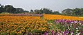 Flower valley
 -
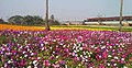 Valley of Flowers in Dokanda


References[edit]
- ^ "Khirai Flowers valley - One day tour from Kolkata Khirai flowers garden". sialoquenter. Retrieved 30 January 2020.
External links[edit]
Cities, towns, locations and neighbourhoods in Purba Medinipur District, Medinipur division | ||||||||||
|---|---|---|---|---|---|---|---|---|---|---|
| Cities, municipal and census towns |
|  | ||||||||
| Locations other than cities and towns |
| |||||||||
| Neighbourhoods |
| |||||||||
| Related topics | ||||||||||