
File:Wpdms nasa topo gila river.jpg
No higher resolution available.
Wpdms_nasa_topo_gila_river.jpg (300 × 300 pixels, file size: 60 KB, MIME type: image/jpeg)
| This is a file from the Wikimedia Commons. Information from its description page there is shown below. Commons is a freely licensed media file repository. You can help. |
Summary
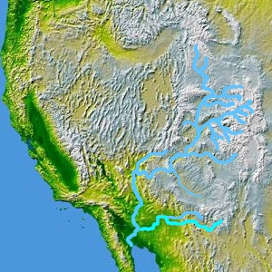
Map showing Colorado River (top), its tributary Gila River, and Gila Rivers tributary Salt River (bottom right). Brought here from enwiki en:Image:Wpdms nasa topo gila river.jpg, GFDL, uploaded there by Decumanus
Licensing
| This file is licensed under the Creative Commons Attribution-Share Alike 3.0 Unported license. Subject to disclaimers. | ||
| ||
| This licensing tag was added to this file as part of the GFDL licensing update. |

|
Permission is granted to copy, distribute and/or modify this document under the terms of the GNU Free Documentation License, Version 1.2 or any later version published by the Free Software Foundation; with no Invariant Sections, no Front-Cover Texts, and no Back-Cover Texts. A copy of the license is included in the section entitled GNU Free Documentation License. Subject to disclaimers. |
File history
Click on a date/time to view the file as it appeared at that time.
| Date/Time | Thumbnail | Dimensions | User | Comment | |
|---|---|---|---|---|---|
| current | 20:51, 16 April 2006 | | 300 × 300 (60 KB) | Habj | Map showing Colorado River (top), its tributary Gila River, and Gila Rivers tributary Salt River (right). Brought here from enwiki en:Image:Wpdms nasa topo gila river.jpg, GFDL, uploaded there by Decumanus [[Category:Gila Rive |
File usage
The following pages on the English Wikipedia use this file (pages on other projects are not listed):
Global file usage
The following other wikis use this file:
- Usage on sv.wikipedia.org