
File:Taoyuan MRT.png

Size of this preview: 800 × 567 pixels. Other resolutions: 320 × 227 pixels | 640 × 454 pixels | 1,024 × 726 pixels | 1,280 × 907 pixels | 2,560 × 1,815 pixels | 4,736 × 3,357 pixels.
Original file (4,736 × 3,357 pixels, file size: 4.11 MB, MIME type: image/png)
| This is a file from the Wikimedia Commons. Information from its description page there is shown below. Commons is a freely licensed media file repository. You can help. |
Summary
| Description |
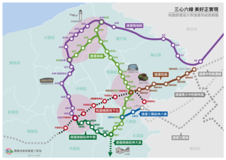
English: Taoyuan Mass Rapid Transit System plannig map
中文:桃園都會區大眾捷運系統計畫路網圖 |
| Date | |
| Source | [1] |
| Author | 中華民國桃園市政府捷運工程局, Department of Rapid Transit Systems, Taoyuan City Government, ROC |
Licensing

|
The copyright holder of this file, Taoyuan City Government, allows anyone to use it for any purpose, provided that the copyright holder is properly attributed. Redistribution, derivative work, commercial use, and all other use is permitted. |
Attribution:
|
|
|
This file is licensed under the Government Website Open Information Announcement.
Information on Related Items:
|
 |
|
|
File history
Click on a date/time to view the file as it appeared at that time.
| Date/Time | Thumbnail | Dimensions | User | Comment | |
|---|---|---|---|---|---|
| current | 03:54, 8 December 2020 | | 4,736 × 3,357 (4.11 MB) | Happy60907 | Update Ver.20200902 |
| 03:52, 8 December 2020 |  | 4,737 × 3,358 (1.24 MB) | Happy60907 | Update Ver.20191008 | |
| 15:43, 29 November 2018 |  | 4,631 × 3,251 (4.12 MB) | Happy60907 | Update Ver.20180719 | |
| 15:33, 27 November 2018 |  | 4,610 × 3,234 (4.07 MB) | Happy60907 | Update Ver.20180424 | |
| 12:19, 19 March 2018 |  | 4,536 × 3,402 (8.51 MB) | Happy60907 | Update Ver.201801 | |
| 08:43, 9 January 2017 |  | 3,402 × 2,552 (6.59 MB) | Happy60907 | 路網圖更新 | |
| 14:56, 14 November 2015 |  | 8,399 × 5,940 (5.17 MB) | Aotfs2013 | 1.大溪延伸線細節化 2.背景調整 等其它調整 / 修改 | |
| 00:28, 2 November 2015 |  | 5,500 × 3,550 (802 KB) | Sahubitula265457 | ||
| 00:40, 30 October 2015 |  | 5,750 × 3,550 (806 KB) | Sahubitula265457 | ||
| 12:45, 18 October 2015 |  | 5,600 × 3,550 (833 KB) | Sahubitula265457 |
File usage
The following pages on the English Wikipedia use this file (pages on other projects are not listed):
Global file usage
The following other wikis use this file:
- Usage on de.wikipedia.org
- Usage on fr.wikipedia.org
- Usage on hak.wikipedia.org
- Usage on ja.wikipedia.org
- Usage on ru.wikipedia.org
- Usage on vi.wikipedia.org
- Usage on zh-min-nan.wikipedia.org
- Usage on zh.wikipedia.org
- Usage on zh.wikivoyage.org