
File:Sino-Vietnamese War - Campaign 1427 cz.svg

Size of this PNG preview of this SVG file: 725 × 569 pixels. Other resolutions: 306 × 240 pixels | 612 × 480 pixels | 979 × 768 pixels | 1,280 × 1,005 pixels | 2,560 × 2,009 pixels.
Original file (SVG file, nominally 725 × 569 pixels, file size: 41 KB)
| This is a file from the Wikimedia Commons. Information from its description page there is shown below. Commons is a freely licensed media file repository. You can help. |
Summary
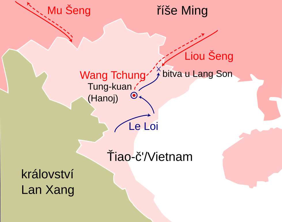
| Description | Map of Vietnam Bounding box West 101.5°, South 7.5°, East 110.5°, North 24°. Center at |
| Date | (UTC) |
| Source |
This file was derived from: Map of Vietnam Demis.png:  |
| Author |
|
| This is a retouched picture, which means that it has been digitally altered from its original version. Modifications: Countries and war campaign 1427. The original can be viewed here: Map of Vietnam Demis.png:
|
Licensing
This image is in the public domain because it came from the site https://www.demis.nl/products/web-map-server/examples/ and was released by the copyright holder. Permission is granted to copy, distribute and/or modify this map since it is based on free of copyright images from: www.demis.nl. See also approval email on de.wp and its clarification.
|
| This work has been released into the public domain by its copyright holder, www.demis.nl. This applies worldwide. In some countries this may not be legally possible; if so: www.demis.nl grants anyone the right to use this work for any purpose, without any conditions, unless such conditions are required by law.
|
Original upload log
This image is a derivative work of the following images:
- File:Map_of_Vietnam_Demis.png licensed with PD-Demis
- 2006-12-20T18:27:15Z Mats Halldin 725x1380 (372327 Bytes) Map of [[Vietnam]] Bounding box West 101.5°, South 7.5°, East 110.5°, North 24°. Center at {{coor d|15.75000|N|106.00000|E|scale:9900000}}. {{demis-pd}} [[category:maps of Vietnam]]
Uploaded with derivativeFX
File history
Click on a date/time to view the file as it appeared at that time.
| Date/Time | Thumbnail | Dimensions | User | Comment | |
|---|---|---|---|---|---|
| current | 19:03, 25 May 2013 | | 725 × 569 (41 KB) | Jann | lepší barvy |
| 18:56, 24 May 2013 |  | 725 × 569 (1.12 MB) | Jann | Change colours | |
| 18:51, 24 May 2013 |  | 725 × 569 (1.12 MB) | Jann | == {{int:filedesc}} == {{Information |Description=Map of Vietnam Bounding box West 101.5°, South 7.5°, East 110.5°, North 24°. Center at |Source={{Derived from|Map_of_Vietnam_Demis.png|display=50}} |Date=2013-05-24 18:40 (UTC) |Author=*[[:File... |
File usage
The following pages on the English Wikipedia use this file (pages on other projects are not listed):
Global file usage
The following other wikis use this file:
- Usage on cs.wikipedia.org