
File:Recknitz.png

Size of this preview: 378 × 599 pixels. Other resolutions: 151 × 240 pixels | 303 × 480 pixels | 485 × 768 pixels | 646 × 1,024 pixels | 1,413 × 2,238 pixels.
Original file (1,413 × 2,238 pixels, file size: 2.95 MB, MIME type: image/png)
| This is a file from the Wikimedia Commons. Information from its description page there is shown below. Commons is a freely licensed media file repository. You can help. |
Summary
| Description |
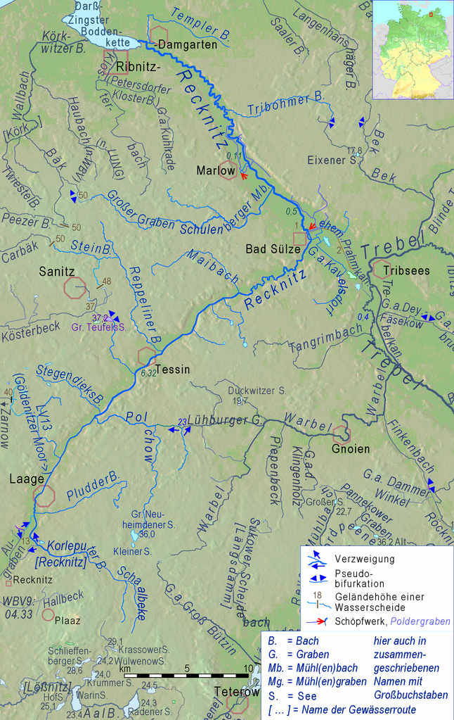
English: Recknitz River and its connections in a cut of Peene river system.
Deutsch: Recknitz und ihre Verbindungen mit Nachbargewässern im Ausschnitt einer physischen Karte des Flusssystems der Peene. |
| Source |
Adapted cut of File:Peene Flusssystem Relief.png , created by myself in 2019 using Openstreetmap & http://www.maps-for-free.html |
| Author | Ulamm (talk) 18:57, 22 November 2013 (UTC) |
Licensing
This file is licensed under the Creative Commons Attribution-Share Alike 3.0 Unported license.
- You are free:
- to share – to copy, distribute and transmit the work
- to remix – to adapt the work
- Under the following conditions:
- attribution – You must give appropriate credit, provide a link to the license, and indicate if changes were made. You may do so in any reasonable manner, but not in any way that suggests the licensor endorses you or your use.
- share alike – If you remix, transform, or build upon the material, you must distribute your contributions under the same or compatible license as the original.
File history
Click on a date/time to view the file as it appeared at that time.
| Date/Time | Thumbnail | Dimensions | User | Comment | |
|---|---|---|---|---|---|
| current | 20:31, 5 April 2019 | | 1,413 × 2,238 (2.95 MB) | Ulamm | completely new map, now an adapted cutout of Peene Flusssystem Relief.png |
| 07:01, 20 May 2016 |  | 463 × 573 (56 KB) | Ulamm | unique revision | |
| 21:06, 19 May 2016 |  | 463 × 573 (56 KB) | Ulamm | Überarbeitungen der "Mutterkarte" übernommen | |
| 15:22, 22 November 2013 |  | 463 × 573 (54 KB) | Ulamm | colours and some borderline names | |
| 14:58, 22 November 2013 |  | 463 × 573 (54 KB) | Ulamm | + locator map | |
| 14:57, 22 November 2013 |  | 463 × 573 (52 KB) | Ulamm | == {{int:filedesc}} == {{Information |Description={{en|1=Recknitz River and its connections in a cut of a relief map of Mecklenburg-Western Pomerania:<br>Brown figures = soil above sea level in meters (measure at the point, name above or below)<br>dark... |
File usage
The following pages on the English Wikipedia use this file (pages on other projects are not listed):
Global file usage
The following other wikis use this file:
- Usage on csb.wikipedia.org
- Usage on da.wikipedia.org
- Usage on de.wikipedia.org
- Usage on fi.wikipedia.org
- Usage on fr.wikipedia.org
- Usage on it.wikipedia.org
- Usage on nl.wikipedia.org
- Usage on pl.wikipedia.org
- Usage on sv.wikipedia.org
- Usage on zh.wikipedia.org