
File:Porter Map of Franz Josef Land Ziegler Expedition.png

Size of this preview: 450 × 600 pixels. Other resolutions: 180 × 240 pixels | 360 × 480 pixels | 576 × 768 pixels | 768 × 1,024 pixels | 2,172 × 2,896 pixels.
Original file (2,172 × 2,896 pixels, file size: 8.76 MB, MIME type: image/png)
| This is a file from the Wikimedia Commons. Information from its description page there is shown below. Commons is a freely licensed media file repository. You can help. |
Summary
| Description |
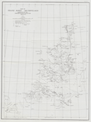
English: Map showing surveys conducted of Franz Josef Land by Russel Porter and Anton Vedoe during the Ziegler-Fiala Polar Expedition. From the Arctic diary of Anton Vedoe - via Norwegian Polar Institute. |
| Date | |
| Source | https://brage.npolar.no/npolar-xmlui/handle/11250/2686680 |
| Author | Russell Williams Porter |
Licensing
This file is licensed under the Creative Commons Attribution 4.0 International license.
- You are free:
- to share – to copy, distribute and transmit the work
- to remix – to adapt the work
- Under the following conditions:
- attribution – You must give appropriate credit, provide a link to the license, and indicate if changes were made. You may do so in any reasonable manner, but not in any way that suggests the licensor endorses you or your use.
File history
Click on a date/time to view the file as it appeared at that time.
| Date/Time | Thumbnail | Dimensions | User | Comment | |
|---|---|---|---|---|---|
| current | 03:56, 16 May 2021 | | 2,172 × 2,896 (8.76 MB) | User-duck | Cropped 3x4 and center using CropTool with lossless mode. |
| 22:02, 15 February 2021 |  | 2,251 × 2,949 (9 MB) | Kaschelott | Uploaded a work by Russell Williams Porter from https://brage.npolar.no/npolar-xmlui/handle/11250/2686680 with UploadWizard |
File usage
The following pages on the English Wikipedia use this file (pages on other projects are not listed):