
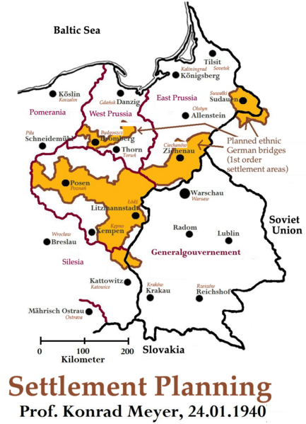
File:Planning Map for Ethnic German Settlement of Warthegau (annexed from Poland).png

Size of this preview: 433 × 599 pixels. Other resolutions: 173 × 240 pixels | 347 × 480 pixels | 555 × 768 pixels | 1,040 × 1,438 pixels.
Original file (1,040 × 1,438 pixels, file size: 993 KB, MIME type: image/png)
| This is a file from the Wikimedia Commons. Information from its description page there is shown below. Commons is a freely licensed media file repository. You can help. |
.png)

|
This map image could be re-created using vector graphics as an SVG file. This has several advantages; see Commons:Media for cleanup for more information. If an SVG form of this image is available, please upload it and afterwards replace this template with
{{vector version available|new image name}}.
It is recommended to name the SVG file “Planning Map for Ethnic German Settlement of Warthegau (annexed from Poland).svg”—then the template Vector version available (or Vva) does not need the new image name parameter. |
Summary
| Description |
English: Planning Map for Ethnic German Settlement of Warthegau (annexed from Poland) |
| Date | |
| Source | https://upload.wikimedia.org/wikipedia/commons/c/c0/Siedlungsplanung_Warthegau.jpg |
| Author | User:Mullerkingdom |
Licensing
This file is licensed under the Creative Commons Attribution-Share Alike 2.5 Generic license.
- You are free:
- to share – to copy, distribute and transmit the work
- to remix – to adapt the work
- Under the following conditions:
- attribution – You must give appropriate credit, provide a link to the license, and indicate if changes were made. You may do so in any reasonable manner, but not in any way that suggests the licensor endorses you or your use.
- share alike – If you remix, transform, or build upon the material, you must distribute your contributions under the same or compatible license as the original.
File history
Click on a date/time to view the file as it appeared at that time.
| Date/Time | Thumbnail | Dimensions | User | Comment | |
|---|---|---|---|---|---|
| current | 01:47, 2 February 2024 | | 1,040 × 1,438 (993 KB) | Keizers | Cropped |
| 01:31, 2 February 2024 |  | 1,281 × 1,508 (1,022 KB) | Keizers | Uploaded a work by User:Mullerkingdom from https://upload.wikimedia.org/wikipedia/commons/c/c0/Siedlungsplanung_Warthegau.jpg with UploadWizard |
File usage
The following pages on the English Wikipedia use this file (pages on other projects are not listed):
.png)