
File:Map of the Upper San Juan Basin.jpg
No higher resolution available.
Map_of_the_Upper_San_Juan_Basin.jpg (562 × 423 pixels, file size: 140 KB, MIME type: image/jpeg)
| This is a file from the Wikimedia Commons. Information from its description page there is shown below. Commons is a freely licensed media file repository. You can help. |
Summary
| Description |
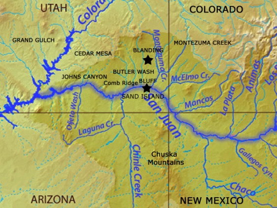
English: Derivative of a map of the upper San Juan River Basin, southwestern US. Additional place names and approximate locations for place names are supplied and/or enhanced. |
| Date | |
| Source | File:Sanjuanrivermap.jpg |
| Author | Shannon |
For use in educational/nonprofit publications and presentations. All modifications are Intended to provide a general guide, not an accurate map.
Licensing
This file is licensed under the Creative Commons Attribution-Share Alike 4.0 International license.
- You are free:
- to share – to copy, distribute and transmit the work
- to remix – to adapt the work
- Under the following conditions:
- attribution – You must give appropriate credit, provide a link to the license, and indicate if changes were made. You may do so in any reasonable manner, but not in any way that suggests the licensor endorses you or your use.
- share alike – If you remix, transform, or build upon the material, you must distribute your contributions under the same or compatible license as the original.
File history
Click on a date/time to view the file as it appeared at that time.
| Date/Time | Thumbnail | Dimensions | User | Comment | |
|---|---|---|---|---|---|
| current | 22:10, 17 February 2015 | | 562 × 423 (140 KB) | Chris Oravec | User created page with UploadWizard |
File usage
The following pages on the English Wikipedia use this file (pages on other projects are not listed):