
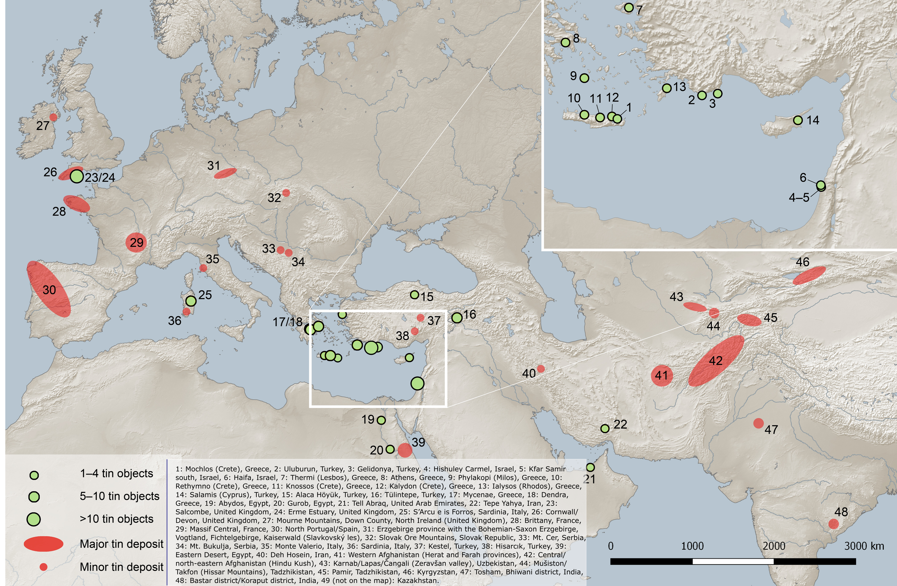
File:Map of bronze-age tin finds. Objects in the eastern Mediterranean and the Near East, and major and minor tin deposits.png
Original file (3,521 × 2,300 pixels, file size: 9.01 MB, MIME type: image/png)
| This is a file from the Wikimedia Commons. Information from its description page there is shown below. Commons is a freely licensed media file repository. You can help. |
Summary
| Description |
English: Map of bronze-age tin finds: objects in the eastern Mediterranean and the Near East, and major and minor tin deposits.
Modified for Wikimedia Commons. The original version can be found at File:Map of Eurasia showing the locations of the tin ingots mentioned in the text (green dots), other tin objects in the eastern Mediterranean and the Near East before 1000 BCE (yellow dots) and major and minor tin deposits.png Legend: 1: Mochlos (Crete), Greece, 2: Uluburun, Turkey, 3: Gelidonya, Turkey, 4: Hishuley Carmel, Israel, 5: Kfar Samir south, Israel, 6: Haifa, Israel, 7: Thermi (Lesbos), Greece, 8: Athens, Greece, 9: Phylakopi (Milos), Greece, 10: Rethymno (Crete), Greece, 11: Knossos (Crete), Greece, 12: Kalydon (Crete), Greece, 13: Ialysos (Rhodos), Greece, 14: Salamis (Cyprus), Turkey, 15: Alaca Höyük, Turkey, 16: Tülintepe, Turkey, 17: Mycenae, Greece, 18: Dendra, Greece, 19: Abydos, Egypt, 20: Gurob, Egypt, 21: Tell Abraq, United Arab Emirates, 22: Tepe Yahya, Iran, 23: Salcombe, United Kingdom, 24: Erme Estuary, United Kingdom, 25: S’Arcu e is Forros, Sardinia, Italy, 26: Cornwall/Devon, United Kingdom, 27: Mourne Mountains, Down County, North Ireland (United Kingdom), 28: Brittany, France, 29: Massif Central, France, 30: North Portugal/Spain, 31: Erzgebirge province with the Bohemian-Saxon Erzgebirge, Vogtland, Fichtelgebirge, Kaiserwald (Slavkovský les), 32: Slovak Ore Mountains, Slovak Republic, 33: Mt. Cer, Serbia, 34: Mt. Bukulja, Serbia, 35: Monte Valerio, Italy, 36: Sardinia, Italy, 37: Kestel, Turkey, 38: Hisarcık, Turkey, 39: Eastern Desert, Egypt, 40: Deh Hosein, Iran, 41: Western Afghanistan (Herat and Farah provinces), 42: Central/north-eastern Afghanistan (Hindu Kush), 43: Karnab/Lapas/Čangali (Zeravšan valley), Uzbekistan, 44: Mušiston/Takfon (Hissar Mountains), Tadzhikistan, 45: Pamir, Tadzhikistan, 46: Kyrgyzstan, 47: Tosham, Bhiwani district, India, 48: Bastar district/Koraput district, India, 49 (not on the map): Kazakhstan. Size of green symbols on the inset map do not correlate with number of objects as on the main map. Original publication: Berger, Daniel (2019-06-26). "Isotope systematics and chemical composition of tin ingots from Mochlos (Crete) and other Late Bronze Age sites in the eastern Mediterranean Sea: An ultimate key to tin provenance?". PLOS ONE 14 (6): e0218326. DOI:10.1371/journal.pone.0218326. PMID 31242218. PMC: 6594607. ISSN 1932-6203. Original map credit: (map: D. Berger, C. Frank using Natural Earth geo data and QGIS Geographic Information System. QGIS Development Team, 2019. Open Source Geospatial Foundation. http://qgis.org). Original map license:
|
||
| Date | |||
| Source | Own work | ||
| Author | Danny lost |
,_other_tin_objects_in_the_eastern_Mediterranean_and_the_Near_East_before_1000_BCE_(yellow_dots)_and_major_and_minor_tin_deposits.png)
Licensing
- You are free:
- to share – to copy, distribute and transmit the work
- to remix – to adapt the work
- Under the following conditions:
- attribution – You must give appropriate credit, provide a link to the license, and indicate if changes were made. You may do so in any reasonable manner, but not in any way that suggests the licensor endorses you or your use.
File history
Click on a date/time to view the file as it appeared at that time.
| Date/Time | Thumbnail | Dimensions | User | Comment | |
|---|---|---|---|---|---|
| current | 19:43, 27 February 2022 | | 3,521 × 2,300 (9.01 MB) | Danny lost | Uploaded own work with UploadWizard |
File usage
Global file usage
The following other wikis use this file:
- Usage on de.wikipedia.org
- Usage on he.wikipedia.org
- Usage on uk.wikipedia.org
- Usage on www.wikidata.org