
File:Map of March 2012 attacks in Toulouse and Montauban, and scarlet Vigipirate area, in France.svg

Size of this PNG preview of this SVG file: 632 × 600 pixels. Other resolutions: 253 × 240 pixels | 506 × 480 pixels | 809 × 768 pixels | 1,079 × 1,024 pixels | 2,158 × 2,048 pixels | 2,000 × 1,898 pixels.
Original file (SVG file, nominally 2,000 × 1,898 pixels, file size: 946 KB)
| This is a file from the Wikimedia Commons. Information from its description page there is shown below. Commons is a freely licensed media file repository. You can help. |
Summary
| Description |
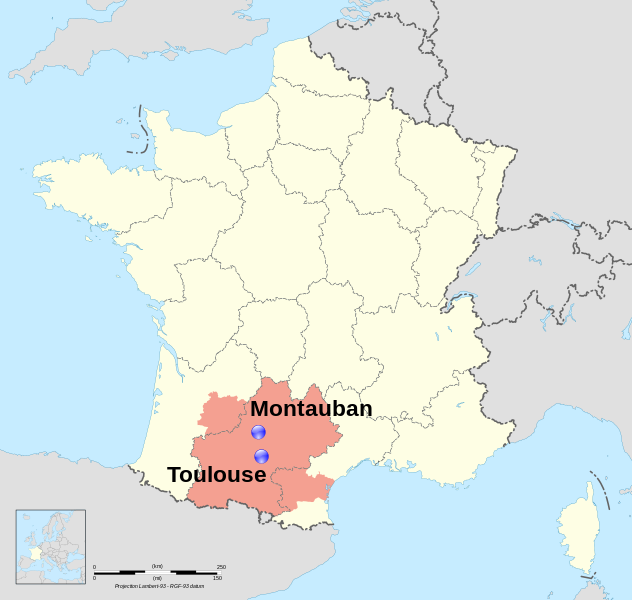
Dansk: Lokalisering af Montauban og Toulouse, to byer i regionen Midi-Pyrénées, Frankrig. I pink, området hvor landets terroralarm, er blevet hævet via Vigipirate. English: Location map of Montauban and Toulouse, two towns in region Midi-Pyrénées, France. In pink, the area covored by the Scarlet Vigipirate level. Français : Carte de localisation de Montauban et Toulouse, deux villes de la région Midi-Pyrénées, France. En rose, la zone couverte par le plan Vigipirate écarlate. |
| Date | (UTC) |
| Source |
This file was derived from: France map Lambert-93 with regions and departments polygons-blank.svg: |
| Author | |
| Attribution (required by the license) | © Sémhur / Wikimedia Commons / |
| SVG development |
Toulouse : region:FR-31 43°36′16″N 1°26′38″E / 43.604482°N 1.443962°E Montauban : region:FR-47 44°01′05″N 1°21′21″E / 44.018056°N 1.355833°E
Licensing
I, the copyright holder of this work, hereby publish it under the following licenses:
This file is licensed under the Creative Commons Attribution-Share Alike Attribution-Share Alike 4.0 International, 3.0 Unported, 2.5 Generic, 2.0 Generic and 1.0 Generic license.
- You are free:
- to share – to copy, distribute and transmit the work
- to remix – to adapt the work
- Under the following conditions:
- attribution – You must give appropriate credit, provide a link to the license, and indicate if changes were made. You may do so in any reasonable manner, but not in any way that suggests the licensor endorses you or your use.
- share alike – If you remix, transform, or build upon the material, you must distribute your contributions under the same or compatible license as the original.
| Copyleft: This work of art is free; you can redistribute it and/or modify it according to terms of the Free Art License. You will find a specimen of this license on the Copyleft Attitude site as well as on other sites. |
You may select the license of your choice.
Original upload log
This image is a of the following images:
- File:France map Lambert-93 with regions and departments polygons-blank.svg licensed with Cc-by-sa-3.0,2.5,2.0,1.0, GFDL
- 2009-02-03T18:58:47Z Sting 2000x1898 (1873536 Bytes) == Summary == {{Location|46|15|00|N|02|06|00|E|scale:5000000}} {{Information |Description={{en|Blank map of {{W|France}} in the official Lambert-93 projection, with regions and departments as independent polygons. '
Uploaded with derivativeFX
File history
Click on a date/time to view the file as it appeared at that time.
| Date/Time | Thumbnail | Dimensions | User | Comment | |
|---|---|---|---|---|---|
| current | 20:32, 25 March 2012 | | 2,000 × 1,898 (946 KB) | Pic-Sou | deleting boundaries |
| 08:44, 23 March 2012 |  | 2,000 × 1,898 (1,004 KB) | Sémhur | bigger text ; vigipirate boundaries | |
| 10:10, 22 March 2012 |  | 2,000 × 1,898 (999 KB) | Sémhur | == {{int:filedesc}} == {{Information |Description={{Multilingual description |en= Location map of en:Montauban and en:Toulouse, two towns in region Midi-Pyrénées, France. |fr= Carte de localisation de fr:Montauban et [[:fr:Toulouse|... |
File usage
The following pages on the English Wikipedia use this file (pages on other projects are not listed):
Global file usage
The following other wikis use this file:
- Usage on ar.wikipedia.org
- Usage on ca.wikipedia.org
- Usage on cs.wikipedia.org
- Usage on da.wikipedia.org
- Usage on es.wikipedia.org
- Usage on eu.wikipedia.org
- Usage on fa.wikipedia.org
- Usage on fi.wikipedia.org
- Usage on fr.wikipedia.org
- Usage on he.wikipedia.org
- Usage on it.wikipedia.org
- Usage on kk.wikipedia.org
- Usage on nds.wikipedia.org
- Usage on nl.wikipedia.org
- Usage on oc.wikipedia.org
- Usage on ro.wikipedia.org
- Usage on ru.wikipedia.org
- Usage on ta.wikipedia.org
- Usage on th.wikipedia.org
- Usage on tr.wikipedia.org
- Usage on uk.wikipedia.org
- Usage on vi.wikipedia.org
- Usage on www.wikidata.org