
File:Madrid snowbound.jpg

Original file (4,438 × 3,524 pixels, file size: 15.04 MB, MIME type: image/jpeg)
| This is a file from the Wikimedia Commons. Information from its description page there is shown below. Commons is a freely licensed media file repository. You can help. |
Summary
| Description |
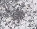
English: Captured by the Copernicus Sentinel-2 mission on 11 January 2021 at 12:14 CET, this image of Madrid in Spain appears to have been taken in black and white. In fact, it is a true-colour image – but the heaviest snowfall in 50 years has blanketed the region, turning the landscape white.
Storm Filomena hit Spain over the weekend, blanketing parts of the country in thick snow and leaving half of the country on red alert. Madrid, one of the worst affected areas, was brought to a standstill with the airport having to be closed, trains cancelled and roads blocked. Although this satellite image was taken after the storm had passed, it is clear to see that much snow still remains, especially in the outskirts of the city. For example, some runways at the airport, which is visible in the top-right of the image, are still covered by snow. The unusual cold weather on the Iberian Peninsula is expected to last until later this week with temperatures forecasted to plunge to –12°C. The race is on to clear roads so that supplies of essential goods such as food supplies and Covid vaccines can be delivered. Copernicus Sentinel-2 is a two-satellite mission. Each satellite carries a high-resolution camera that images Earth’s surface in 13 spectral bands. Together they cover all Earth’s land surfaces, large islands, inland and coastal waters every five days at the equator. Credits: contains modified Copernicus Sentinel data (2021), processed by ESA, CC BY-SA 3.0 IGO |
| Date | |
| Source | https://www.flickr.com/photos/europeanspaceagency/50827370368/ - Madrid snowbound |
| Author | European Space Agency |
| Other versions |
|
| Activity | Observing the Earth |
| Mission | Sentinel-2 |
| System | Copernicus |
| Camera location | | View this and other nearby images on: OpenStreetMap |
|---|
Licensing

|
This image contains data from a satellite in the Copernicus Programme, such as Sentinel-1, Sentinel-2 or Sentinel-3. Attribution is required when using this image.
Attribution: Contains modified Copernicus Sentinel data 2021
The use of Copernicus Sentinel Data is regulated under EU law (Commission Delegated Regulation (EU) No 1159/2013 and Regulation (EU) No 377/2014). Relevant excerpts:
Free access shall be given to GMES dedicated data [...] made available through GMES dissemination platforms [...].
Access to GMES dedicated data [...] shall be given for the purpose of the following use in so far as it is lawful:
GMES dedicated data [...] may be used worldwide without limitations in time.
GMES dedicated data and GMES service information are provided to users without any express or implied warranty, including as regards quality and suitability for any purpose. |
This media was created by the European Space Agency (ESA).
Where expressly so stated, images or videos are covered by the Creative Commons Attribution-ShareAlike 3.0 IGO (CC BY-SA 3.0 IGO) licence, ESA being an Intergovernmental Organisation (IGO), as defined by the CC BY-SA 3.0 IGO licence. The user is allowed under the terms and conditions of the CC BY-SA 3.0 IGO license to Reproduce, Distribute and Publicly Perform the ESA images and videos released under CC BY-SA 3.0 IGO licence and the Adaptations thereof, without further explicit permission being necessary, for as long as the user complies with the conditions and restrictions set forth in the CC BY-SA 3.0 IGO licence, these including that:
See the ESA Creative Commons copyright notice for complete information, and this article for additional details.
|
 | |
This file is licensed under the Creative Commons Attribution-ShareAlike 3.0 IGO license. Attribution: ESA, CC BY-SA IGO 3.0
| ||
| This image was originally posted to Flickr by europeanspaceagency at https://flickr.com/photos/37472264@N04/50827370368. It was reviewed on 12 January 2021 by FlickreviewR 2 and was confirmed to be licensed under the terms of the cc-by-sa-2.0. |
| Annotations | This image is annotated: View the annotations at Commons |

|
This image has been assessed under the valued image criteria and is considered the most valued image on Commons within the scope: Satellite picture of Storm Filomena, snowfall over the Community of Madrid.. You can see its nomination here. |
File history
Click on a date/time to view the file as it appeared at that time.
| Date/Time | Thumbnail | Dimensions | User | Comment | |
|---|---|---|---|---|---|
| current | 14:46, 12 January 2021 | | 4,438 × 3,524 (15.04 MB) | Up and Go | Uploaded a work by European Space Agency from https://www.flickr.com/photos/europeanspaceagency/50827370368/ with UploadWizard |
File usage
Global file usage
The following other wikis use this file:
- Usage on es.wikipedia.org
- Usage on pt.wikipedia.org