
File:Karte Werdenberger.png

Size of this preview: 410 × 600 pixels. Other resolutions: 164 × 240 pixels | 328 × 480 pixels | 525 × 768 pixels | 700 × 1,024 pixels | 1,500 × 2,194 pixels.
Original file (1,500 × 2,194 pixels, file size: 615 KB, MIME type: image/png)
| This is a file from the Wikimedia Commons. Information from its description page there is shown below. Commons is a freely licensed media file repository. You can help. |
| Description |
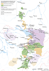
Deutsch: Karte des Herrschaftsgebiets der Grafen von Werdenberg und von Montfort im 14./15. Jahrhundert |
|
| Date | ||
| Source | Own work | |
| Author | Marco Zanoli (sidonius 13:29, 3 March 2007 (UTC)) | |
| Permission (Reusing this file) |
|
File history
Click on a date/time to view the file as it appeared at that time.
| Date/Time | Thumbnail | Dimensions | User | Comment | |
|---|---|---|---|---|---|
| current | 09:21, 3 January 2023 | | 1,500 × 2,194 (615 KB) | Sidonius | Ursern entfernt |
| 20:18, 27 December 2022 |  | 1,500 × 2,264 (623 KB) | Sidonius | mehrere Korrekturen, Legende in Beschriftung ausgelagert, Layout angepasst | |
| 04:57, 4 July 2010 |  | 1,000 × 1,752 (210 KB) | DcoetzeeBot | Remove watermark, add author and license data to image metadata, decrease filesize with pngcrush | |
| 13:29, 3 March 2007 |  | 1,000 × 1,752 (319 KB) | Sidonius | {{Information |Description={{de|Karte des Herrschaftsgebiets der Grafen von Werdenberg und von Montfort im 14. Jahrhundert}} |Source=own work |Date=3.3.2007 |Author=Marco Zanoli (~~~~) |Permission={{Attribution sidoniu |
File usage
The following pages on the English Wikipedia use this file (pages on other projects are not listed):
Global file usage
The following other wikis use this file:
- Usage on als.wikipedia.org
- Usage on ca.wikipedia.org
- Usage on de.wikipedia.org
- Usage on es.wikipedia.org
- Usage on fr.wikipedia.org
- Usage on nl.wikipedia.org
- Usage on pl.wikipedia.org